|
02047500
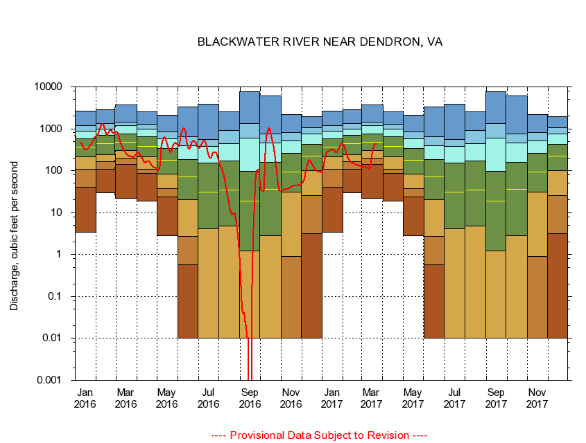
BLACKWATER RIVER NEAR DENDRON, VA
|
Minimum daily flow
|
|
|
5th percentile
|
|
|
|
10th percentile
|
|
|
|
|
25th percentile
|
|
|
|
|
|
Median
|
|
|
|
|
|
|
75th percentile
|
|
|
|
|
|
|
|
90th percentile
|
|
|
|
|
|
|
|
|
95th percentile
|
|
|
|
|
|
|
|
|
|
Maximum daily flow
|
|
|
|
|
|
|
|
|
|
|
|
Years of record
|
January
|
3.41
|
41.0
|
108
|
213
|
363
|
573
|
890
|
1,190
|
2,680
|
|
72
|
February
|
29.4
|
110
|
162
|
245
|
446
|
688
|
992
|
1,330
|
2,900
|
|
72
|
March
|
22.0
|
142
|
201
|
303
|
478
|
757
|
1,170
|
1,450
|
3,730
|
|
72
|
April
|
18.6
|
85.4
|
110
|
215
|
376
|
638
|
980
|
1,260
|
2,580
|
|
72
|
May
|
2.86
|
24.1
|
37.7
|
83.6
|
177
|
344
|
570
|
848
|
2,130
|
|
72
|
June
|
0.00
|
0.57
|
2.72
|
20.6
|
71.7
|
187
|
394
|
638
|
3,300
|
|
72
|
July
|
0.00
|
0.00
|
0.01
|
4.08
|
30.7
|
150
|
380
|
559
|
3,880
|
|
72
|
August
|
0.00
|
0.00
|
0.00
|
4.84
|
34.4
|
173
|
446
|
904
|
2,500
|
|
72
|
September
|
0.00
|
0.00
|
0.00
|
1.20
|
19.0
|
96.2
|
611
|
1,310
|
7,710
|
|
73
|
October
|
0.00
|
0.00
|
0.00
|
2.79
|
35.7
|
156
|
453
|
750
|
6,140
|
|
72
|
November
|
0.00
|
0.00
|
0.89
|
31.0
|
93.4
|
262
|
516
|
813
|
2,200
|
|
73
|
December
|
0.00
|
3.18
|
25.9
|
101
|
220
|
426
|
755
|
1,080
|
1,970
|
|
73
|
|
|
|