|
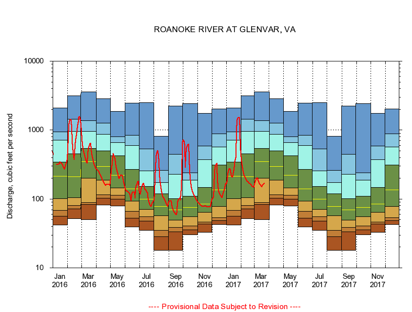
02054530
ROANOKE RIVER AT GLENVAR, VA
|
Minimum daily flow
|
|
|
5th percentile
|
|
|
|
10th percentile
|
|
|
|
|
25th percentile
|
|
|
|
|
|
Median
|
|
|
|
|
|
|
75th percentile
|
|
|
|
|
|
|
|
90th percentile
|
|
|
|
|
|
|
|
|
95th percentile
|
|
|
|
|
|
|
|
|
|
Maximum daily flow
|
|
|
|
|
|
|
|
|
|
|
|
Years of record
|
January
|
41.9
|
56.3
|
68.2
|
101
|
213
|
345
|
713
|
940
|
2,100
|
|
24
|
February
|
51.9
|
71.7
|
81.0
|
105
|
210
|
453
|
959
|
1,440
|
3,160
|
|
24
|
March
|
49.9
|
83.4
|
88.9
|
199
|
351
|
542
|
953
|
1,360
|
3,590
|
|
24
|
April
|
81.4
|
103
|
115
|
189
|
296
|
501
|
875
|
1,260
|
2,870
|
|
24
|
May
|
78.6
|
99.9
|
113
|
144
|
220
|
421
|
657
|
794
|
1,860
|
|
24
|
June
|
39.6
|
52.9
|
65.9
|
93.0
|
140
|
268
|
601
|
839
|
2,460
|
|
24
|
July
|
35.1
|
47.8
|
55.2
|
70.5
|
99.4
|
151
|
255
|
530
|
2,510
|
|
24
|
August
|
18.0
|
28.2
|
34.9
|
57.4
|
77.4
|
119
|
172
|
261
|
819
|
|
24
|
September
|
17.9
|
33.3
|
38.7
|
49.0
|
69.1
|
101
|
229
|
442
|
2,220
|
|
24
|
October
|
30.1
|
35.4
|
40.9
|
54.9
|
75.7
|
110
|
187
|
238
|
2,410
|
|
23
|
November
|
33.1
|
43.4
|
46.6
|
63.7
|
84.1
|
147
|
373
|
584
|
1,750
|
|
23
|
December
|
42.3
|
48.4
|
53.9
|
77.4
|
135
|
313
|
566
|
888
|
2,040
|
|
23
|
|
|
|