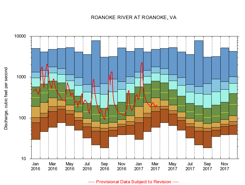
USGS - science for a changing world
Virginia DEQ

Virginia Water Science Center

 
  Duration Plot and Table of 7-Day Average Streamflow
 
02055000 ROANOKE RIVER AT ROANOKE, VA
LOCATION.--Latitude 37°15'30", Longitude 79°56'20", North American Datum of 1927,
                    Roanoke City, VA, Hydrologic Unit 03010101.
DRAINAGE AREA.--384 square miles.
PERIOD OF RECORD.--February 1899 to current year. Monthly discharge only for some periods, published in WSP 1303. Records for July 1896 to January 1899 published in WSP 11, 15, 27, and 20th Annual Report, Part 4, are unreliable, due to doubtful gage-height record, and should not be used.
DURATION STATISTIC COMPUTATION PERIOD.--All data through September 2015.
REGULATION.--Prior to 1949, diurnal fluctuation caused by powerplants. After 1994, withdrawal of 11.1 cfs.
GAGE OPERATION.--U.S. Geological Survey, Virginia Water Science Center.

     Duration Plot with 7-Day Average Streamflow Conditions
Provisional Data Subject to Revision
02055000 plot. 
ROANOKE RIVER AT ROANOKE, VA
Provisional Data Subject to Revision


The current 7-day running-average value for 03/22/2017 is 205.29 cubic feet per second.

  explanation   Percentile Description Duration Plot Description 28 Day 14 Day 7 Day Daily


      Duration Table of 7-Day Average Streamflow
           
Flow values in cubic feet per second


                02055000     ROANOKE RIVER AT ROANOKE, VA

   Minimum daily flow
   5th percentile
 
   10th percentile
 
   25th percentile
 
 
   Median
 
 
   75th percentile


   90th percentile


   95th percentile


   Maximum daily flow
         
Years of record
January
30.0
77.1
102
192
316
574
956
1,330
5,040
 
115
February
46.1
103
131
241
409
679
1,040
1,470
4,180
 
117
March
59.3
144
191
313
507
799
1,270
1,790
4,830
 
117
April
76.3
165
193
275
417
721
1,170
1,620
5,070
 
117
May
64.9
124
151
208
304
489
814
1,140
5,340
 
117
June
50.1
86.6
102
140
201
342
631
970
4,150
 
117
July
32.3
60.9
73.3
98.1
143
229
428
654
3,590
 
117
August
21.7
47.6
59.0
83.7
123
202
399
588
7,850
 
117
September
18.6
46.7
56.0
73.1
102
172
379
687
3,090
 
117
October
34.9
50.5
59.0
78.0
111
207
436
902
3,210
 
115
November
38.6
61.6
70.3
91.1
136
244
495
770
5,250
 
115
December
39.1
66.3
81.5
114
213
399
703
1,030
4,260
 
115


The current 7-day running-average value for 03/22/2017 is 205.29 cubic feet per second.

---- Provisional Data Subject to Revision ----

Accessibility FOIA Privacy Policies and Notices

Take Pride in America logo USA.gov logo U.S. Department of the Interior | U.S. Geological Survey
URL: http://va.water.usgs.gov/duration_plots/htm_7/dp02055000.htm
Page Contact Information: Virginia WSC Webmaster
Page Last Modified: 6/19/2016