|
02059500
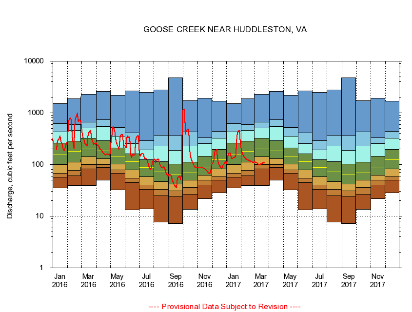
GOOSE CREEK NEAR HUDDLESTON, VA
|
Minimum daily flow
|
|
|
5th percentile
|
|
|
|
10th percentile
|
|
|
|
|
25th percentile
|
|
|
|
|
|
Median
|
|
|
|
|
|
|
75th percentile
|
|
|
|
|
|
|
|
90th percentile
|
|
|
|
|
|
|
|
|
95th percentile
|
|
|
|
|
|
|
|
|
|
Maximum daily flow
|
|
|
|
|
|
|
|
|
|
|
|
Years of record
|
January
|
35.3
|
56.8
|
68.3
|
99.9
|
154
|
258
|
430
|
615
|
1,520
|
|
85
|
February
|
39.0
|
61.3
|
76.9
|
112
|
180
|
283
|
461
|
589
|
1,860
|
|
85
|
March
|
39.6
|
81.9
|
99.1
|
141
|
202
|
325
|
507
|
659
|
2,280
|
|
85
|
April
|
49.7
|
88.3
|
99.7
|
129
|
182
|
289
|
546
|
745
|
2,610
|
|
85
|
May
|
32.1
|
67.9
|
79.4
|
103
|
144
|
208
|
355
|
519
|
2,190
|
|
85
|
June
|
13.3
|
45.1
|
54.9
|
79.6
|
113
|
161
|
253
|
413
|
2,630
|
|
85
|
July
|
14.0
|
33.3
|
40.0
|
58.7
|
87.3
|
123
|
192
|
290
|
2,480
|
|
85
|
August
|
7.64
|
24.9
|
32.7
|
46.6
|
71.6
|
115
|
228
|
372
|
2,770
|
|
85
|
September
|
7.19
|
24.1
|
30.7
|
42.3
|
63.4
|
102
|
187
|
363
|
4,810
|
|
85
|
October
|
13.7
|
26.6
|
35.9
|
50.1
|
69.0
|
112
|
230
|
429
|
1,710
|
|
84
|
November
|
21.9
|
39.9
|
50.0
|
61.4
|
85.9
|
145
|
253
|
331
|
1,910
|
|
85
|
December
|
28.1
|
50.0
|
57.7
|
82.3
|
124
|
194
|
323
|
440
|
1,700
|
|
85
|
|
|
|