|
02061000
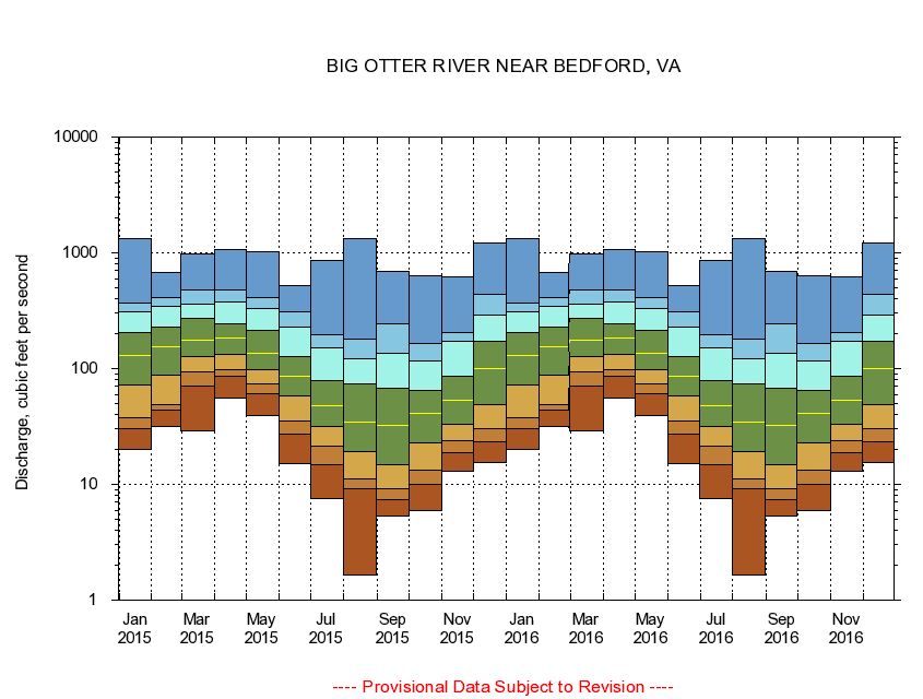
BIG OTTER RIVER NEAR BEDFORD, VA
|
Minimum daily flow
|
|
|
5th percentile
|
|
|
|
10th percentile
|
|
|
|
|
25th percentile
|
|
|
|
|
|
Median
|
|
|
|
|
|
|
75th percentile
|
|
|
|
|
|
|
|
90th percentile
|
|
|
|
|
|
|
|
|
95th percentile
|
|
|
|
|
|
|
|
|
|
Maximum daily flow
|
|
|
|
|
|
|
|
|
|
|
|
Years of record
|
January
|
19.9
|
30.6
|
37.3
|
72.3
|
129
|
205
|
309
|
371
|
1,340
|
|
25
|
February
|
31.6
|
43.4
|
48.6
|
87.6
|
156
|
230
|
348
|
408
|
678
|
|
25
|
March
|
28.9
|
71.2
|
93.7
|
127
|
176
|
269
|
359
|
474
|
983
|
|
25
|
April
|
55.7
|
86.3
|
98.2
|
133
|
183
|
246
|
379
|
482
|
1,070
|
|
25
|
May
|
38.9
|
60.3
|
73.9
|
98.0
|
135
|
215
|
333
|
412
|
1,030
|
|
25
|
June
|
15.1
|
26.9
|
35.4
|
58.6
|
85.5
|
128
|
226
|
307
|
523
|
|
25
|
July
|
7.46
|
14.8
|
21.3
|
31.4
|
47.4
|
79.1
|
151
|
194
|
851
|
|
24
|
August
|
1.66
|
9.16
|
11.1
|
19.2
|
34.7
|
74.5
|
122
|
178
|
1,320
|
|
24
|
September
|
5.33
|
7.33
|
9.15
|
14.8
|
32.6
|
67.0
|
135
|
246
|
686
|
|
24
|
October
|
5.89
|
10.1
|
13.4
|
22.6
|
41.3
|
65.1
|
117
|
164
|
632
|
|
23
|
November
|
12.9
|
18.6
|
24.1
|
32.7
|
52.9
|
85.9
|
172
|
206
|
623
|
|
24
|
December
|
15.3
|
23.3
|
30.3
|
48.4
|
101
|
173
|
290
|
434
|
1,220
|
|
24
|
|
|
|