|
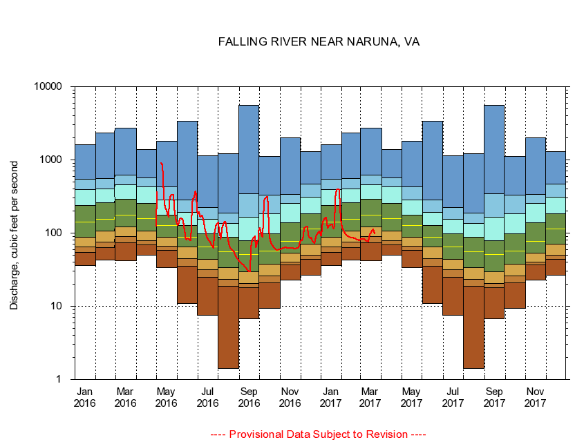
02064000
FALLING RIVER NEAR NARUNA, VA
|
Minimum daily flow
|
|
|
5th percentile
|
|
|
|
10th percentile
|
|
|
|
|
25th percentile
|
|
|
|
|
|
Median
|
|
|
|
|
|
|
75th percentile
|
|
|
|
|
|
|
|
90th percentile
|
|
|
|
|
|
|
|
|
95th percentile
|
|
|
|
|
|
|
|
|
|
Maximum daily flow
|
|
|
|
|
|
|
|
|
|
|
|
Years of record
|
January
|
35.7
|
54.0
|
64.7
|
88.3
|
141
|
240
|
397
|
542
|
1,630
|
|
79
|
February
|
42.9
|
63.3
|
75.9
|
106
|
156
|
260
|
400
|
560
|
2,330
|
|
79
|
March
|
42.1
|
73.4
|
90.0
|
121
|
176
|
291
|
461
|
614
|
2,700
|
|
78
|
April
|
50.4
|
69.3
|
78.9
|
106
|
158
|
253
|
427
|
563
|
1,400
|
|
78
|
May
|
34.1
|
58.7
|
66.1
|
87.4
|
126
|
175
|
285
|
429
|
1,800
|
|
78
|
June
|
11.0
|
35.2
|
45.0
|
65.1
|
88.3
|
126
|
191
|
285
|
3,390
|
|
78
|
July
|
7.54
|
25.1
|
31.3
|
44.0
|
64.4
|
97.9
|
153
|
223
|
1,150
|
|
78
|
August
|
1.41
|
18.9
|
23.4
|
33.4
|
56.0
|
87.0
|
136
|
187
|
1,220
|
|
78
|
September
|
6.71
|
18.1
|
20.6
|
29.9
|
51.4
|
78.4
|
165
|
343
|
5,550
|
|
78
|
October
|
9.34
|
21.1
|
26.0
|
37.9
|
57.3
|
98.1
|
184
|
332
|
1,110
|
|
78
|
November
|
22.6
|
36.6
|
40.0
|
53.6
|
77.7
|
139
|
254
|
341
|
2,020
|
|
79
|
December
|
26.6
|
43.8
|
49.9
|
70.9
|
113
|
183
|
307
|
463
|
1,290
|
|
79
|
|
|
|