|
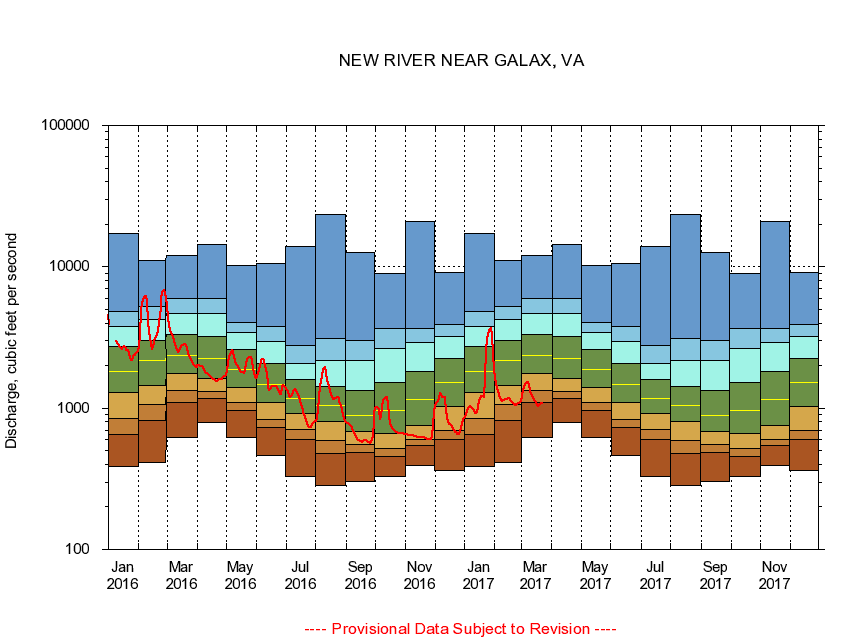
03164000
NEW RIVER NEAR GALAX, VA
|
Minimum daily flow
|
|
|
5th percentile
|
|
|
|
10th percentile
|
|
|
|
|
25th percentile
|
|
|
|
|
|
Median
|
|
|
|
|
|
|
75th percentile
|
|
|
|
|
|
|
|
90th percentile
|
|
|
|
|
|
|
|
|
95th percentile
|
|
|
|
|
|
|
|
|
|
Maximum daily flow
|
|
|
|
|
|
|
|
|
|
|
|
Years of record
|
January
|
387
|
652
|
851
|
1,300
|
1,820
|
2,720
|
3,800
|
4,850
|
17,100
|
|
86
|
February
|
413
|
823
|
1,060
|
1,440
|
2,160
|
3,010
|
4,250
|
5,220
|
11,100
|
|
86
|
March
|
617
|
1,100
|
1,340
|
1,760
|
2,340
|
3,300
|
4,710
|
6,010
|
12,000
|
|
86
|
April
|
798
|
1,180
|
1,320
|
1,630
|
2,250
|
3,210
|
4,680
|
5,980
|
14,400
|
|
86
|
May
|
617
|
969
|
1,100
|
1,410
|
1,890
|
2,580
|
3,430
|
4,060
|
10,300
|
|
86
|
June
|
464
|
724
|
830
|
1,090
|
1,470
|
2,060
|
2,970
|
3,780
|
10,600
|
|
86
|
July
|
327
|
603
|
705
|
920
|
1,180
|
1,590
|
2,080
|
2,770
|
13,900
|
|
86
|
August
|
283
|
481
|
592
|
803
|
1,040
|
1,420
|
2,190
|
3,100
|
23,500
|
|
86
|
September
|
304
|
487
|
556
|
684
|
887
|
1,330
|
2,190
|
3,010
|
12,600
|
|
86
|
October
|
329
|
452
|
515
|
657
|
965
|
1,530
|
2,650
|
3,660
|
9,000
|
|
85
|
November
|
390
|
548
|
601
|
759
|
1,160
|
1,820
|
2,930
|
3,640
|
21,100
|
|
86
|
December
|
360
|
597
|
691
|
1,020
|
1,510
|
2,260
|
3,220
|
3,900
|
9,180
|
|
86
|
|
|
|