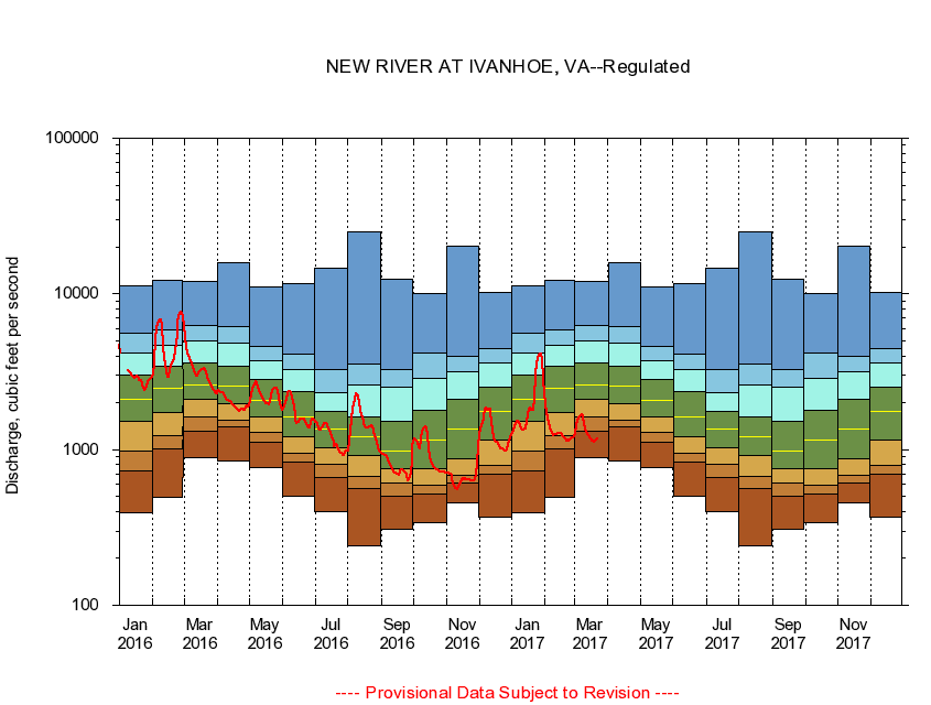
USGS - science for a changing world
Virginia DEQ

Virginia Water Science Center

 
  Duration Plot and Table of 7-Day Average Streamflow
 
03165500 NEW RIVER AT IVANHOE, VA
LOCATION.--Latitude 36°50'05", Longitude 80°57'10", North American Datum of 1927,
                    Wythe County, VA, Hydrologic Unit 05050001.
DRAINAGE AREA.--1,350 square miles.
PERIOD OF RECORD.--August to December 1927, October 1929 to September 1978, February 1996 to current year. Monthly discharge only for some periods, published in WSP 1305. Gage-height records collected in vicinity, October 1916 to July 1943, are contained in reports of the National Weather Service.
DURATION STATISTIC COMPUTATION PERIOD.--All data through September 2015.
REGULATION.--Flow regulated by powerplants about 2.8 and 5.5 miles upstream.
GAGE OPERATION.--U.S. Geological Survey, Virginia Water Science Center.

     Duration Plot with 7-Day Average Streamflow Conditions
Provisional Data Subject to Revision
03165500 plot. 
NEW RIVER AT IVANHOE, VA
Provisional Data Subject to Revision


The current 7-day running-average value for 03/22/2017 is 1161.29 cubic feet per second.

  explanation   Percentile Description Duration Plot Description 28 Day 14 Day 7 Day Daily


      Duration Table of 7-Day Average Streamflow
           
Flow values in cubic feet per second


                03165500     NEW RIVER AT IVANHOE, VA

   Minimum daily flow
   5th percentile
 
   10th percentile
 
   25th percentile
 
 
   Median
 
 
   75th percentile


   90th percentile


   95th percentile


   Maximum daily flow
         
Years of record
January
390
727
978
1,520
2,120
2,990
4,200
5,570
11,200
 
68
February
492
1,010
1,230
1,730
2,460
3,420
4,710
5,920
12,300
 
69
March
887
1,310
1,610
2,090
2,620
3,610
4,980
6,250
12,100
 
69
April
842
1,410
1,550
1,960
2,550
3,430
4,860
6,130
15,800
 
69
May
762
1,110
1,290
1,630
2,080
2,810
3,740
4,570
11,100
 
69
June
503
837
940
1,210
1,630
2,340
3,260
4,100
11,700
 
69
July
398
660
805
1,030
1,360
1,770
2,310
3,280
14,600
 
69
August
240
559
668
911
1,200
1,630
2,590
3,540
24,900
 
69
September
310
505
611
751
984
1,530
2,530
3,280
12,500
 
70
October
337
515
594
756
1,160
1,780
2,850
4,200
10,100
 
68
November
456
608
686
877
1,360
2,090
3,170
3,980
20,400
 
69
December
367
692
793
1,150
1,760
2,530
3,590
4,480
10,200
 
69


The current 7-day running-average value for 03/22/2017 is 1161.29 cubic feet per second.

---- Provisional Data Subject to Revision ----

Accessibility FOIA Privacy Policies and Notices

Take Pride in America logo USA.gov logo U.S. Department of the Interior | U.S. Geological Survey
URL: http://va.water.usgs.gov/duration_plots/htm_7/dp03165500.htm
Page Contact Information: Virginia WSC Webmaster
Page Last Modified: 6/19/2016