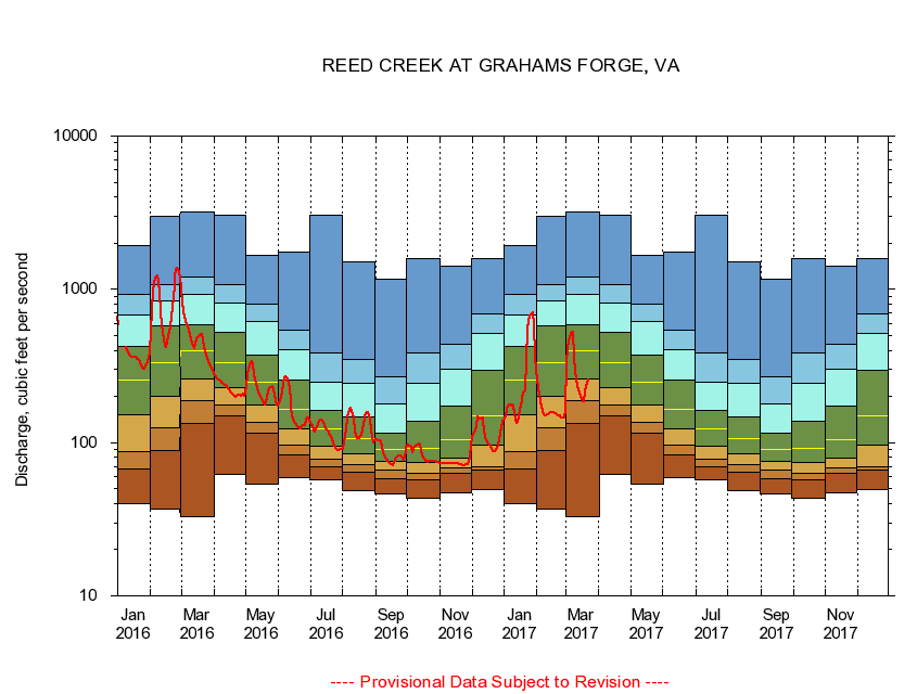
USGS - science for a changing world
Virginia DEQ

Virginia Water Science Center

 
  Duration Plot and Table of 7-Day Average Streamflow
 
03167000 REED CREEK AT GRAHAMS FORGE, VA
LOCATION.--Latitude 36°56'22", Longitude 80°53'13", North American Datum of 1927,
                    Wythe County, VA, Hydrologic Unit 05050001.
DRAINAGE AREA.--258 square miles.
PERIOD OF RECORD.--July 1908 to September 1916, January 1927 to current year. Monthly discharge only for some periods, published in WSP 1305.
DURATION STATISTIC COMPUTATION PERIOD.--All data through September 2015.
REGULATION.--Minimal diurnal fluctuation caused by mill.
GAGE OPERATION.--U.S. Geological Survey, Virginia Water Science Center.

     Duration Plot with 7-Day Average Streamflow Conditions
Provisional Data Subject to Revision
03167000 plot. 
REED CREEK AT GRAHAMS FORGE, VA
Provisional Data Subject to Revision


The current 7-day running-average value for 03/22/2017 is 255.14 cubic feet per second.

  explanation   Percentile Description Duration Plot Description 28 Day 14 Day 7 Day Daily


      Duration Table of 7-Day Average Streamflow
           
Flow values in cubic feet per second


                03167000     REED CREEK AT GRAHAMS FORGE, VA

   Minimum daily flow
   5th percentile
 
   10th percentile
 
   25th percentile
 
 
   Median
 
 
   75th percentile


   90th percentile


   95th percentile


   Maximum daily flow
         
Years of record
January
40.1
67.4
86.6
152
254
425
676
932
1,930
 
96
February
36.9
89.0
124
200
333
575
843
1,070
3,010
 
96
March
32.9
134
187
260
396
591
922
1,210
3,200
 
96
April
61.7
150
175
228
332
522
820
1,080
3,030
 
96
May
53.3
115
135
177
246
372
614
796
1,660
 
97
June
59.0
83.1
95.7
122
166
254
402
544
1,740
 
97
July
57.1
69.9
77.8
95.1
122
161
246
383
3,020
 
97
August
48.4
63.6
72.1
85.1
107
148
243
346
1,520
 
97
September
46.6
58.3
65.7
75.0
90.3
115
180
268
1,170
 
97
October
43.6
57.4
63.1
74.7
91.9
138
243
386
1,580
 
95
November
47.1
63.3
68.1
79.3
104
172
303
437
1,420
 
96
December
49.0
65.7
69.6
96.0
150
297
512
690
1,580
 
96


The current 7-day running-average value for 03/22/2017 is 255.14 cubic feet per second.

---- Provisional Data Subject to Revision ----

Accessibility FOIA Privacy Policies and Notices

Take Pride in America logo USA.gov logo U.S. Department of the Interior | U.S. Geological Survey
URL: http://va.water.usgs.gov/duration_plots/htm_7/dp03167000.htm
Page Contact Information: Virginia WSC Webmaster
Page Last Modified: 6/19/2016