|
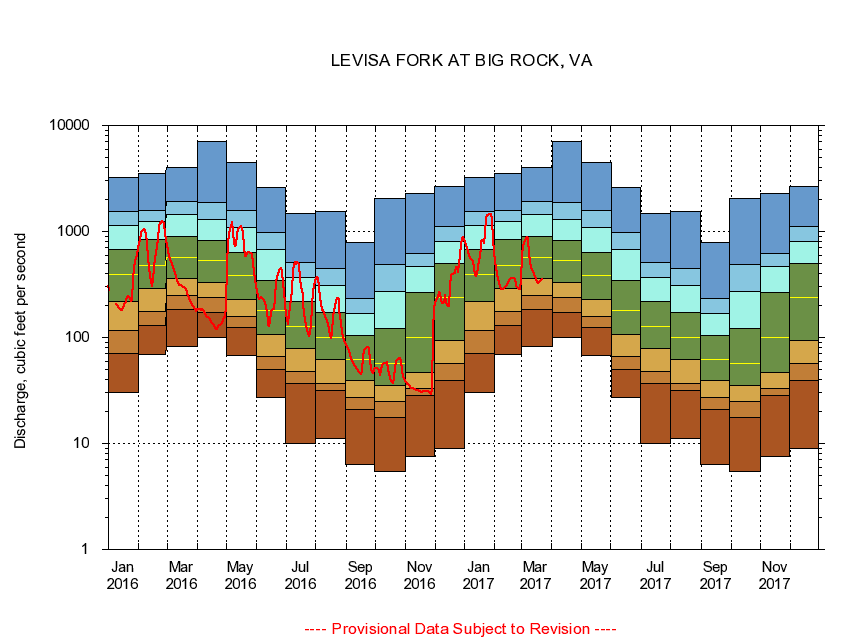
03207800
LEVISA FORK AT BIG ROCK, VA
|
Minimum daily flow
|
|
|
5th percentile
|
|
|
|
10th percentile
|
|
|
|
|
25th percentile
|
|
|
|
|
|
Median
|
|
|
|
|
|
|
75th percentile
|
|
|
|
|
|
|
|
90th percentile
|
|
|
|
|
|
|
|
|
95th percentile
|
|
|
|
|
|
|
|
|
|
Maximum daily flow
|
|
|
|
|
|
|
|
|
|
|
|
Years of record
|
January
|
30.3
|
70.3
|
116
|
218
|
395
|
672
|
1,140
|
1,540
|
3,230
|
|
48
|
February
|
69.0
|
131
|
177
|
292
|
473
|
838
|
1,250
|
1,590
|
3,520
|
|
48
|
March
|
83.1
|
185
|
250
|
357
|
564
|
890
|
1,460
|
1,930
|
4,000
|
|
48
|
April
|
100
|
173
|
237
|
333
|
527
|
820
|
1,300
|
1,860
|
7,030
|
|
48
|
May
|
67.6
|
125
|
159
|
230
|
381
|
638
|
1,080
|
1,570
|
4,430
|
|
48
|
June
|
27.1
|
49.9
|
65.9
|
107
|
179
|
345
|
673
|
981
|
2,610
|
|
48
|
July
|
9.91
|
36.5
|
47.7
|
78.9
|
126
|
220
|
370
|
505
|
1,470
|
|
48
|
August
|
11.2
|
31.4
|
37.0
|
61.6
|
99.4
|
171
|
308
|
444
|
1,540
|
|
48
|
September
|
6.36
|
20.9
|
27.4
|
39.1
|
62.3
|
105
|
168
|
231
|
794
|
|
48
|
October
|
5.47
|
17.6
|
25.0
|
35.4
|
57.4
|
122
|
274
|
488
|
2,040
|
|
47
|
November
|
7.56
|
28.1
|
33.0
|
46.5
|
101
|
266
|
466
|
622
|
2,260
|
|
48
|
December
|
9.06
|
39.2
|
56.5
|
94.6
|
238
|
504
|
812
|
1,110
|
2,640
|
|
48
|
|
|
|