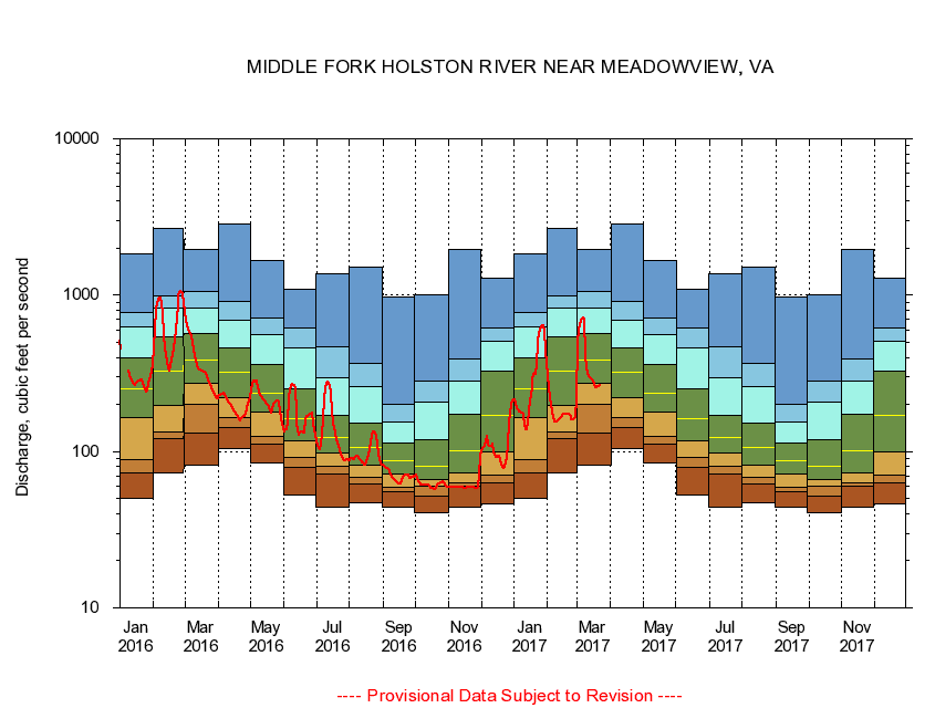
USGS - science for a changing world
Virginia DEQ

Virginia Water Science Center

 
  Duration Plot and Table of 7-Day Average Streamflow
 
03475000 MIDDLE FORK HOLSTON RIVER NEAR MEADOWVIEW, VA
LOCATION.--Latitude 36°42'47", Longitude 81°49'08", North American Datum of 1927,
                    Washington County, VA, Hydrologic Unit 06010102.
DRAINAGE AREA.--206 square miles.
PERIOD OF RECORD.--October 1931 to September 1953, May 1976 to current year. Monthly discharge only for October 1931, published in WSP 1306.
DURATION STATISTIC COMPUTATION PERIOD.--May 1976 through September 2015.
REGULATION.--Flow regulated by powerplant about 0.9 mile above gage prior to 1954.
GAGE OPERATION.--U.S. Geological Survey, Virginia Water Science Center.

     Duration Plot with 7-Day Average Streamflow Conditions
Provisional Data Subject to Revision
03475000 plot. 
MIDDLE FORK HOLSTON RIVER NEAR MEADOWVIEW, VA
Provisional Data Subject to Revision


The current 7-day running-average value for 03/22/2017 is 262.43 cubic feet per second.

  explanation   Percentile Description Duration Plot Description 28 Day 14 Day 7 Day Daily


      Duration Table of 7-Day Average Streamflow
           
Flow values in cubic feet per second


                03475000     MIDDLE FORK HOLSTON RIVER NEAR MEADOWVIEW, VA

   Minimum daily flow
   5th percentile
 
   10th percentile
 
   25th percentile
 
 
   Median
 
 
   75th percentile


   90th percentile


   95th percentile


   Maximum daily flow
         
Years of record
January
49.9
72.8
89.3
166
253
397
629
770
1,850
 
39
February
72.6
120
134
198
328
537
829
990
2,690
 
39
March
81.6
132
199
273
384
573
830
1,060
1,950
 
39
April
105
142
164
222
322
463
690
909
2,830
 
39
May
84.1
112
125
179
236
360
559
710
1,670
 
39
June
52.4
78.9
92.3
118
163
250
458
621
1,090
 
40
July
44.4
71.3
80.7
97.4
123
169
294
466
1,380
 
40
August
46.9
62.0
68.5
82.1
106
151
261
369
1,510
 
40
September
44.3
55.4
59.1
71.3
87.7
114
155
202
976
 
40
October
40.7
52.1
59.7
66.3
81.0
119
207
284
1,010
 
39
November
44.1
60.4
63.4
72.5
101
173
282
391
1,970
 
39
December
46.4
62.9
70.3
98.9
171
328
507
619
1,280
 
39


The current 7-day running-average value for 03/22/2017 is 262.43 cubic feet per second.

---- Provisional Data Subject to Revision ----

Accessibility FOIA Privacy Policies and Notices

Take Pride in America logo USA.gov logo U.S. Department of the Interior | U.S. Geological Survey
URL: http://va.water.usgs.gov/duration_plots/htm_7/dp03475000.htm
Page Contact Information: Virginia WSC Webmaster
Page Last Modified: 6/19/2016