
|
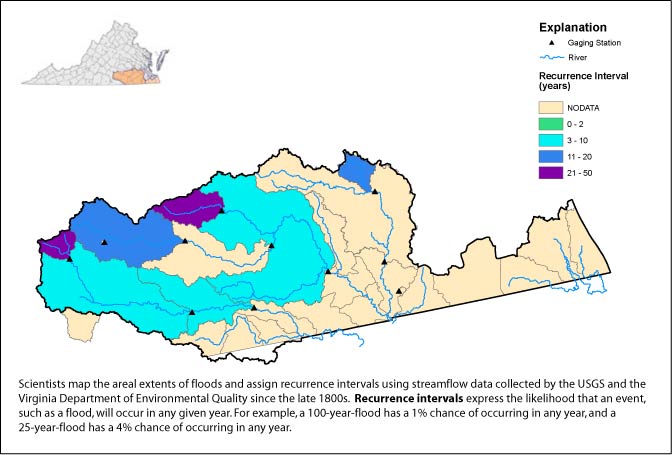
Flood Recurrence Interval: Chowan Basin |
||
|
||
|
||
| Click here for data in Excel | ||
| SITE_ID | NAME | DRAINAGE AREA |
DATE | TIME | GAGE HT |
DISCHARGE | RECURRENCE INTERVAL |
REMARKS |
| 02044200 | "Falls Creek Trib near Victoria, Va." | 0.34 | -- | -- | -- | -- | -- | -- |
| 02044500 | "Nottoway River near Rawlings, Va." | 309 | 9/20/2003 | 1:00AM | 16.77 | 14299 | 15 | -- |
| 02045500 | "Nottoway River near Stony Creek, Va." | 579 | -- | -- | -- | -- | -- | -- |
| 02046000 | "Stony Creek near Dinwiddie, Va." | 112 | 9/19/2003 | 1:45PM | 19.11 | 9270 | 50 | -- |
| 02047000 | "Nottoway River near Sebrell, Va." | 1421 | 9/23/2003 | 12:30PM | 24.71 | 18600 | 10 | -- |
| 02047500 | "Blackwater River near Dendron, Va." | 294 | 9/22/2003 | 10:00PM | 10.62 | 5610 | 20 | -- |
| 02049500 | "Blackwater River near Franklin, Va." | 617 | -- | -- | -- | -- | -- | Phone line out |
| 02050050 | "Blackwater River Trib near Holland, Va." | 2.76 | -- | -- | -- | -- | -- | -- |
| 02051000 | "North Meherrin River near Lunenburg, Va." | 55.6 | 9/19/2003 | 3:00AM | 23.86 | 7180 | 25 | -- |
| 02051500 | "Meherrin River near Lawrenceville, Va." | 552 | 9/20/2003 | 9:00PM | 28.67 | 14599 | 10 | -- |
| 02052000 | "Meherrin River at Emporia, Va." | 747 | 9/19/2003 | 3:15PM | 23.66 | 13600 | 5 | -- |
| 02079640 | "Allen Creek near Boydton, Va." | 53.4 | -- | -- | -- | -- | -- | -- |
|
USGS--Water Resources of Virginia Contact: GS-W-VArmd_webmaster@usgs.gov URL://va.water.usgs.gov/floodwatch/basins/chowan_sept24_03.htm Last modified: 09/26/03 06:43:08 AM |