
By Gary K. Speiran, Pixie A. Hamilton, and Michael D. Woodside
Summary of Findings and Management Implications
|
Nitrogen, phosphorus, and suspended sediment are contaminants that have widely contributed to the deterioration in the water quality of Chesapeake Bay and other surface waters throughout Virginia and the United States. These contaminants are derived from various sources and are transported to surface waters by surface (overland) runoff and ground-water discharge. Nitrogen and phosphorus stimulate growth of algae (eutrophication) and have been blamed, in part, for a decrease in the abundance of fish in Chesapeake Bay.
Agricultural and residential application of fertilizers, land application of animal waste, discharge from septic tanks, and precipitation are major sources of nitrate (a common form of nitrogen) that leaches into ground water. As ground water flows through shallow aquifers and discharges to surface waters, it can contribute large amounts of nitrate to the surface waters.
Forests adjacent to surface waters provide buffers that remove phosphorus and sediment from surface runoff. Numerous studies also have indicated that forest buffers remove much of the nitrate in ground water that flows beneath them from agricultural fields. A recent study (1991 - 93) on the Eastern Shore of Virginia (fig. 1), however, indicates that a variety of factors other than the presence of forest buffers actually control the amount of nitrate discharging from ground water to surface waters (Speiran, 1996). Knowledge of these factors is important to the management of nitrate in ground water that discharges to Chesapeake Bay and other surface waters. This report highlights major results of that study.
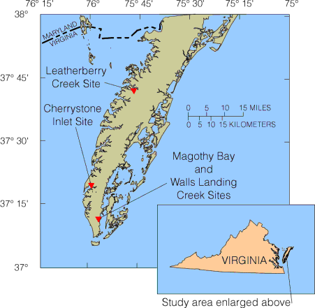 |
Figure 1. Location of the Eastern Shore, Virginia, and local study area.
Contrary to popular belief, ground water does not form underground rivers in ground-water systems that consist of unconsolidated sediment. Instead, water fills, and flows slowly through, tiny spaces between sediment grains. Water-bearing layers consisting of gravel, sand, and silt, are known as aquifers. Aquifers are separated from one another by layers of clay and silt, known as confining units. Water flows more freely through aquifers than it does through confining units. The aquifer overlying the uppermost confining unit is known as the water-table aquifer; deeper aquifers are known as confined aquifers. Although confining units retard the flow of water between the aquifers, some downward and upward flow occurs.
Percolation of precipitation through the soil to the water table, a process known as recharge, is the source of water to the water-table aquifer. Most exposed land is part of the recharge area. Water flows from recharge areas down through the aquifers and back up to areas of low elevation, where it discharges to wetlands, streams, agricultural ditches and ponds, bays, and the Atlantic Ocean. As a result of slow flow and long flow pathways, water can remain in the water-table aquifer for several decades.
The water-table aquifer was the focus of this study. For the purposes of this report, "shallow" ground water refers to water in the upper part of the water-table aquifer; "deep" ground water refers to water in the lower part of the water-table aquifer.
Rates and pathways of ground-water flow, and the likelihood that ground water will be contaminated by nitrate, depend on a combination of factors. These factors include soil and aquifer composition, land use, and topography.
The grain size of soil and aquifer sediment affects the rates and pathways of ground-water flow. Coarse-grained sediment forms permeable aquifers through which water readily flows. Fine-grained sediment forms low-permeability aquifers (and confining units) that retard ground-water flow.
The amount of organic material in soil and aquifer sediment affects water chemistry. The amount of organic material generally is minimal in coarse-grained sediment and tends to be more abundant in fine-grained sediment. Organic material reacts with dissolved oxygen, removing it from the water. In areas where organic material is abundant, dissolved oxygen can become rapidly depleted.
Soil composition, topography, and land use commonly reflect the factors that affect ground-water flow and chemistry. Coarse-grained and well-drained soil that contains little organic material often indicates the presence of underlying coarse-grained aquifer sediment that also drains well and contains little organic material. Large upland agricultural fields are commonly located where these sediments are present. Fine-grained and poorly drained soil that contains abundant organic material often indicates the presence of underlying fine-grained aquifer sediment that also drains poorly and contains abundant organic material. Lowland forests and marshes and small fields interspersed in upland forests are commonly located in these areas unless extensive measures are used to drain the land.
The availability of dissolved oxygen and organic material affects the potential for nitrate contamination of ground water. Nitrogen is present in several forms in ground water, and it is transformed differently among these forms depending on the availability of dissolved oxygen and organic material. Where dissolved oxygen is abundant, bacteria chemically oxidize (nitrify) ammonia to nitrate. Nitrate is of concern because it is the one form of nitrogen that readily dissolves in, and flows with, ground water. Where dissolved oxygen is limited, nitrate will not form, and bacteria chemically reduce (denitrify) nitrate that is already present to nitrogen gas (the most common product), or to ammonia if sufficient organic material is present.
U.S. Geological Survey (USGS) hydrologists studied the factors that affect the distribution of nitrate in the water-table aquifer at four small watersheds (less than 3 square miles each) (fig. 1). Each site was selected to represent different environments of ground-water flow and chemistry.
The Leatherberry Creek site located on a small peninsula, represents a system in which precipitation recharges the water-table aquifer through upland forests and agricultural fields underlain primarily by poorly drained and fine-grained sediment that contains abundant organic material. Precipitation also recharges the water-table aquifer through agricultural fields underlain by local deposits of coarse-grained sediment that contains little organic material near Leatherberry Creek. Ground water flows from the fields beneath a 100-ft wide forest buffer that covers a steep slope adjacent to Leatherberry Creek. This water discharges to the creek.
The age of the water increased with depth and along ground-water flow paths; the age was as much as 39 years at a depth of 19 ft near the end of the pathways (fig. 2). Consequently, ground-water chemistry reflects the effects of land use as early as 1954. Water recharged through the coarse-grained sediment near Leatherberry Creek is younger and flows along shorter, shallower pathways than water recharged through the fine-grained sediment farther from the creek.
Dissolved-oxygen concentration was 1 milligram per liter (mg / L) or less, and nitrate was not detectable in water recharged through fine-grained sediment beneath the fields (fig. 2). Dissolved-oxygen concentration, however, ranged from 1.7 to 6.8 mg / L and nitrate concentration ranged from 9.9 to 14 mg / L as nitrogen (N) in water recharged through coarse-grained sediment beneath the fields. Beneath the forest buffer, dissolved oxygen concentration remained 4.5 to 6.3 mg / L in the shallow ground water but was near 0 mg/L in the deep ground water. Similarly, nitrate concentration was 11 to 14 mg / L in the shallow ground water but less than the detectable concentration in the deep ground water.
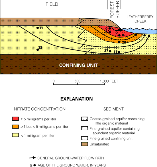 |
Figure 2. Schematic of nitrate concentration in, and age of, ground water at Leatherberry Creek.
The deep ground water beneath the forest buffer reflects the effects of the abundant organic material in the sediment through which it was recharged. The shallow ground water reflects the limited effects of the little organic material in the sediment through which it was recharged beneath the fields. These results indicate that the organic content of the sediment through which precipitation recharged the water-table aquifer is a primary control on nitrate concentration, and the presence of the forest buffer had little effect on nitrate concentration. Where organic material was abundant, either nitrate was not formed from ammonia, or nitrate that was formed or applied directly to the fields was denitrified.
A second site, Cherrystone Inlet, represents a system in which precipitation recharges the water-table aquifer through upland agricultural fields underlain by coarse-grained sediment that contains little organic material. Part of the water discharges directly through the coarse-grained sediment to the Cherrystone Inlet (fig. 3A). Part of the water discharges diffusely to the inlet and to a 500-ft wide forest buffer adjacent to the inlet through locally deposited, fine-grained sediment that overlies the coarse-grained sediment (fig. 3B). The fine-grained sediment is as much as 12 ft thick, contains abundant organic material, and is present locally in areas of low land-surface elevation. The fine-grained sediment has been eroded along parts of the shore where coarse-grained sediment directly borders the inlet.
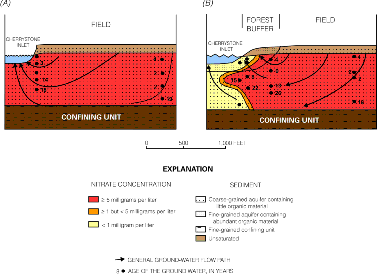 |
Figure 3. Schematics of nitrate concentration in, and age of, ground water at Cherrystone Inlet: (A) coarse-grained sediments adjacent to inlet; (B) fine-grained sediments adjacent to inlet.
The age of the water ranged from 0 to 26 years and increased with depth and along pathways of ground-water flow (fig. 3). Thus, the chemistry of the oldest ground water reflects the effects of land use as early as 1968.
Dissolved-oxygen concentration ranged from 8.0 to less than 1.0 mg / L and decreased with depth and along ground-water flow paths. Nitrate concentration ranged from 7.7 to 27 mg / L as N in water beneath the agricultural field. The lowest nitrate concentration (0.13 mg / L) was in water in the fine-grained sediment.
Ground-water levels and specific conductance values indicate that water discharges readily through the coarse-grained sediment adjacent to the Cherrystone Inlet, thereby potentially introducing elevated nitrate concentrations into the receiving inlet. Ground water also discharges diffusely and sluggishly through the fine-grained sediment. This provides the opportunity for denitrification of nitrate because of the abundant organic material. These two discharge patterns are consistent with the distribution of measured ground-water discharge and nitrate concentration in Cherrystone Inlet (Reay and others, 1992). Vertical gradients in ground-water levels indicate that water also discharges seasonally from the system by evapotranspiration in the forest buffer overlying the fine-grained sediment.
The low nitrate concentration likely resulted from a combination of denitrification caused by the abundant organic material present in the fine-grained sediment, dilution from recharge by precipitation that fell on the forest buffer, and dilution from recharge by salty water that contains little nitrate and occasionally inundates fine-grained lowland sediment during unusually high tides. Thus, sediment composition has a major effect on ground-water flow and chemistry.
A third site, Magothy Bay, represents a system in which precipitation recharges through agricultural fields underlain by coarse-grained sediment that contains little organic material. The water-table aquifer is also recharged through parts of an adjacent forest buffer by precipitation and surface runoff from the fields. Water flows from the fields beneath the 1,600-ft wide forest buffer toward an adjacent saltwater marsh and Magothy Bay. The forest buffer and marsh are underlain by a mixture of fine-grained and coarse-grained sediment that contains variable amounts of organic material.
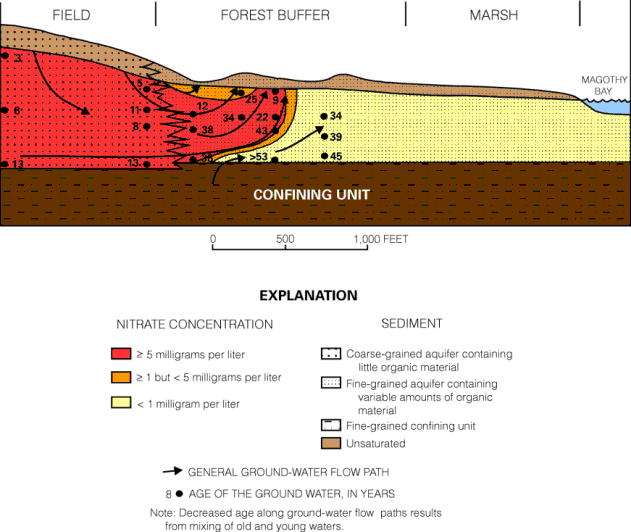 |
Figure 4. Schematic of nitrate concentration in, and age of, ground water at Magothy Bay.
The age of water increased with depth beneath the agricultural fields and along ground-water flow paths (fig. 4). Water was less than 15 years old 30 ft below the water table beneath the fields and more than 53 years old within 15 ft of the water table beneath the forest buffer. The oldest ground water reflects effects of land use before 1940.
Dissolved-oxygen concentration in water beneath the agricultural fields decreased with depth and ranged from 4.2 to 9.0 mg L. Concentration decreased to less than 1 mg / L in water beneath the forest buffer, primarily because of increased organic content of the sediment and contact time between the water and organic material.
The nitrate concentration in water beneath the agricultural fields ranged from 7.8 to 22 mg / L as N (fig. 4). The nitrate concentration beneath the forest buffer was about 2 mg / L as N in shallow ground water within 200 ft of the edge of the field, but was as great as 8 mg / L as N in deep ground water more than 500 ft from the field. Furthermore, the nitrate concentration was about 3.7 mg / L as N beneath the forest buffer more than 850 ft from the fields and did not decrease to near the detectable concentration at all depths beneath the forest buffer until 1,200 ft from the agricultural fields (fig. 4). This distance is considerably greater than the commonly reported 100 to 200 ft needed for the removal of most nitrate from water near the water table beneath forest buffers.
Ground-water flow and chemistry are the primary controls on the distribution of nitrate beneath the forest buffer. Deep ground water reflects the effects of recharge through upland agricultural fields, whereas shallow ground water reflects the effects of recharge through nearby land. The nitrate concentration was low in shallow ground water near the field because of the combined effects of denitrification in runoff from the fields recharging through the organic-rich forest buffer soil and dilution by recharging low-nitrate precipitation. The nitrate concentration in water beneath the forest buffer decreases at increased distance from the agricultural fields because of the (1) discharge of high nitrate water from the water-table aquifer to land surface, (2) discharge of low-nitrate water into the water-table aquifer from the underlying confined aquifer, and (3) denitrification caused by increased organic content in sediment and decreased dissolved-oxygen concentration in the water.
Differences in saturated thickness of the water-table aquifer and the gradient of the water table are the primary factors that cause water to discharge from the aquifer. Lateral and vertical differences in water levels and chemistry, hydraulic calculations, and ground-water age indicate that water generally discharges to land surface within 1,000 ft of the edge of the agricultural fields. Ground water discharges to the surface because the saturated thickness of the water-table aquifer and the gradient of the water table decrease from the agricultural fields to the forest buffer, thereby limiting ground-water flow. The saturated thickness decreases because land-surface elevation decreases and the clay and silt content of the sediment increases. The water-table gradient beneath the forest buffer decreases because land surface is flat and close to sea level.
A large part of the ground water that discharges in the forest buffer does so by evapotranspiration, as indicated by daily cycles in ground-water levels during warm-weather months. Estimated rates of ground-water discharge by evapotranspiration ranged from 10.9 to 37.6 inches from June 2 through August 31, 1993.
The fourth site, Walls Landing Creek, represents a system in which precipitation recharges the water-table aquifer through agricultural fields underlain by coarse-grained sediment that contains little organic material (the site is adjacent to the Magothy Bay site). The ground water flows from the fields beneath a forest buffer and discharges to Walls Landing Creek, a non-tidal creek. The flood plain extends about 250 ft south of the creek, contains a forest buffer, and is underlain by sediment that contains a mineral and organic content different from that of upland sediment.
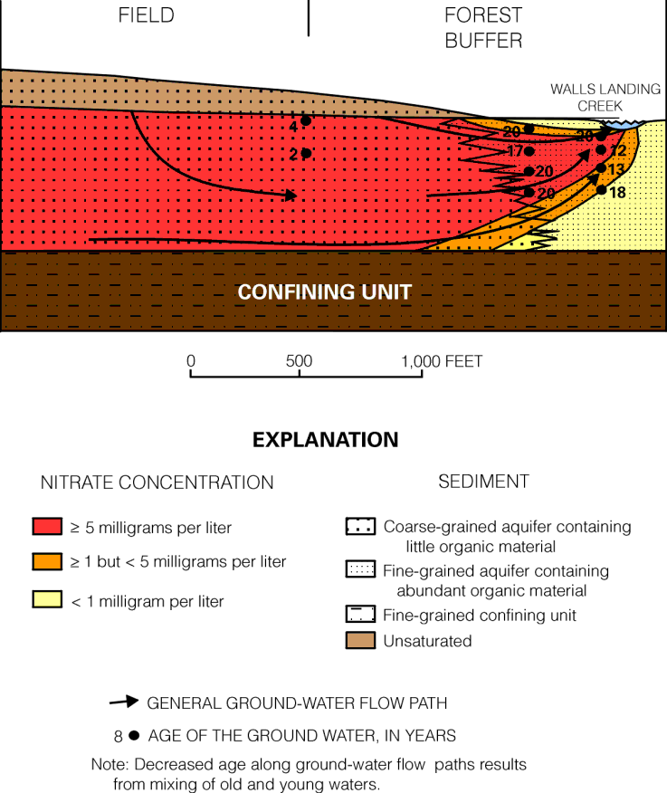 |
Figure 5. Schematic of nitrate concentration in, and age of, ground water at Walls Landing Creek.
The age of the water was less than 15 years beneath the agricultural fields (fig. 4) and ranged from 11.5 to 20 years beneath the forest buffer (fig. 5).
Dissolved-oxygen concentration in water beneath the agricultural fields ranged from 3.8 to 9.0 mg / L. Dissolved-oxygen concentration remained high beneath the forest buffer 125 ft from the agricultural fields, particularly in water greater than 4 ft below the water table, where the concentration ranged from 3.8 to 6.3 mg /L. The dissolved-oxygen concentration adjacent to the creek, however, was less than 1.0 mg / L.
Nitrate concentration in water beneath the agricultural fields ranged from 6.6 to 21 mg / L as N (fig. 5). Similar to dissolved oxygen, nitrate concentration remained high (9.7 to 14 mg / L as N) in deep ground water beneath the forest buffer 125 ft from the agricultural fields. Nitrate was not detectable in ground water within 2 ft of the water table 125 ft from the field. Nitrate concentration was elevated (6.0 mg / L as N) in water 5 ft below the water table and decreased with depth to near the detectable concentration adjacent to Walls Landing Creek.
Land use, ground-water flow, and chemical processes along ground-water flow paths control nitrate concentration in the ground water. Water containing elevated concentrations of nitrate recharged the water-table aquifer beneath upland agricultural fields, flowed beneath the forest buffer and discharged directly to Walls Landing Creek, about 250 ft from the fields. Low nitrate water near the water table beneath the forest buffer reflected the effects of recharge through forest soil having abundant organic material. The nitrate concentration decreased with depth near the creek as a result of denitrification caused by changes in sediment composition. These changes in sediment composition, however, do not result from the current presence of the forest buffer.
Results of this study indicate that nitrate concentration in ground water is affected by soil and aquifer composition, land use, topography, and rates and pathways of ground-water flow. Thus, natural factors beyond the presence or absence of forest buffers control the amount of nitrate in ground water that discharges to surface waters. Specifically, results demonstrate the following:
- Ground water having elevated nitrate concentration as a result of recharge through agricultural fields can flow a few feet below the water table beneath forest buffers hundreds of feet wide and directly discharge to surface waters. This ground water can bypass the effects that forest buffers have on the quality of shallow ground water.
- Grain size and the organic content of soil and aquifer sediment through which water recharges, flows, and discharges are primary controls on the flow and chemistry of ground water and, consequently, control the amount of nitrate discharged to surface waters.
- Differences in land-surface elevation and soil composition from uplands to lowlands accompany differences in aquifer composition, water-level gradients, and saturated thickness of the water-table aquifer. These changes cause ground water to discharge to the surface within lowland forest buffers, thereby limiting the amount of ground water flowing beneath the buffers and discharging directly to surface waters.
- Evapotranspiration through forest buffers is an important discharge pathway for ground water. Plant uptake of at least part of the nitrate dissolved in this water can decrease the amount of nitrate discharged to surface waters.
- Soil characteristics that affect the land use also can directly affect ground-water flow and chemistry. For example, large agricultural fields generally are present in well-drained upland areas underlain by coarse-grained sediment with minimal organic material. Nitrate can move readily through the soil to the ground water in this environment. Lowland forests and marshes and small agricultural fields interspersed in upland forests commonly are present in poorly drained areas having fine-grained soil and underlying aquifer sediment rich in organic material. Denitrification is likely to occur in this environment independent of the land use, and decreases in nitrate concentration beneath forest buffers in these areas can be mistakenly attributed to the presence of forest buffers rather than to subsurface environment.
- Water can remain in the water-table aquifer for several decades. Consequently, the quality of ground water reflects combined effects of land use when the water was recharged and subsequent processes that alter the chemistry of the water as it flows through the aquifer.
These findings have important implications for crop-management practices, land-use planning, and water-resources management. Where the abundance of organic material in soil and aquifer sediment and the pathways of ground-water flow sufficiently enhance denitrification and otherwise limit the amount of nitrate in ground water that discharges to surface waters, these processes can be relied on to naturally protect surface-water quality. These areas, however, need to be managed in a manner such that ground water does not bypass the natural processes. Extensive ditching can cause ground water to bypass the areas and depth intervals in which these processes influence ground water.
Where the soil and aquifer composition, land use, topography, and rates and pathways of ground-water flow do not sufficiently reduce the amount of nitrate in discharging ground water, alternative planning and management strategies are needed. In particular, alternative strategies are needed where (1) upland and lowland sediment is coarse-grained and contains little organic material to denitrify nitrate in ground water; and (2) forest buffers are relatively narrow so that ground water readily flows beneath the buffers and discharges to surface waters. In these areas, comprehensive nutrient management would be appropriate.
Study results also suggest that to evaluate the effectiveness of crop-management strategies designed to reduce the amount of nitrate leaving the root zone, one must understand how soil and aquifer composition, land use, topography, and ground-water flow affect water chemistry over time and space. Studies of water near the water table are not adequate because of the depth that ground water flows. Additionally, age of the ground water is a factor. Decades may pass before water chemistry changes near the ends of long ground-water flow pathways. Consequently, changes in surface-water quality also might lag changes in agricultural practices by years or decades.
Finally, study results suggest that further investigations are needed to determine (1) the degree to which forest buffers affect the quality of water recharging through the buffers and the quality of water flowing under the buffer; (2) the combination of width of forest buffers, aquifer composition, aquifer thickness, and topography that causes ground water to discharge primarily to the surface in forest buffers rather than to surface waters; (3) the effects of forest buffer soils on the quality of ground water that discharges to the surface in the forest buffer; (4) the fate of nitrate in ground water evapotranspired by forest buffers; and (5) the management practices that will sufficiently reduce the amount of nitrate that leaches into ground water.
For More Information, Contact:
District Chief
U.S. Geological Survey
1730 East Parham Road
Richmond, VA 23228
(804) 261-2600

or

Gary Speiran
(804) 261-2642

http://va.water.usgs.gov/

Prepared in Cooperation with
THE COUNTIES OF ACCOMACK AND NORTHAMPTON, AND
THE ACCOMACK-NORTHAMPTON PLANNING DISTRICT COMMISSION
January 1998
Reay, W.G., Gallagher, D.L., and Simmons, G.M., Jr., 1992,
Ground-water discharge and its impacts on surface water quality
in a Chesapeake Bay inlet: Water Resources Bulletin, v. 28,
p. 1121-1134.

Speiran, G.K., 1996, Geohydrology and geochemistry near coastal
ground-water-discharge areas of the Eastern Shore, Virginia:
U.S. Geological Survey Water-Supply Paper 2479, 73 p.

This Fact Sheet is Based on the USGS Water-Supply Paper referenced above.
06/21/00 10:24:46 AM