Virginia Water Science Center
Project Information Title: Numbers: Location: Cooperating Agencies: Project Chiefs: Period of Project: USGS IN YOUR STATEUSGS Water Science Centers are located in each state.  |
Virginia Bankfull Regional Curves ProjectsBackground Stream channels often are disturbed by human activities
or natural events. In recent years, scientists and engineers have begun to
apply the principles of natural channel design to the construction and
restoration of stream channels. Natural channel design involves rebuilding
a channel with the appropriate cross section dimensions, slope, and
plan-view pattern so that it can pass the water and sediment loads
supplied to it while maintaining its appropriate form. Stream channels
designed to approximate natural stable conditions are more likely to
remain in equilibrium over time and therefore reduce erosion and
sedimentation, provide suitable aquatic habitat, and offer increased
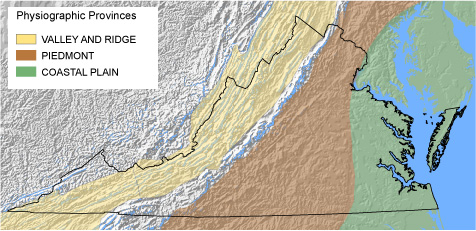
aesthetic and recreational value. Problem A concept central to the methodology of natural channel design is that of effective or “bankfull” discharge. Bankfull discharge, which typically has a return interval of between 1 and 2 years, is considered to be the streamflow magnitude that is most effective in moving sediment and in forming average morphological characteristics of channels. The bankfull channel geometry characteristics of cross-sectional area, width, and average depth have been shown to be highly correlated with both discharge and drainage area. Regionally based relations between drainage area and the resultant bankfull channel geometry are important tools for designing and restoring stable stream channels. Bankfull characteristics used to develop these “regional curves” must be calibrated at stream gage locations and stratified by hydro-physiographic province. Regional curves developed for the hydro-physiographic provinces in Virginia will greatly benefit natural channel design projects in the state. Relevance and Benefits Properly developed regional curves for a specific hydro-physiographic province are an invaluable tool for stream restoration design. Development of regional curves specifically for physiographic provinces of Virginia will enhance the ability to develop successful natural channel designs based on climatic, geologic, and hydrologic characteristics of specific regions of the state. Completed and Active Research
Map of Study Areas: (hyper linked)
Piedmont (active) |

![]() U.S. Department of the Interior
| U.S. Geological Survey
U.S. Department of the Interior
| U.S. Geological Survey
URL: https://va.water.usgs.gov/projects/reg_curves_main.htm
Page Contact Information:
webmaster-va@usgs.gov
Page Last
Modified:
03/31/2010 14:14