|
|
|
Regional
Curves Project

Background
Stream channels often are disturbed by human activities or natural events. In recent years, scientists and engineers have begun to apply the principles of natural channel design to the construction and restoration of stream channels. Natural channel design involves rebuilding a channel with the appropriate cross section dimensions, slope, and plan-view pattern so that it can pass the water and sediment loads supplied to it while maintaining its appropriate form. Stream channels designed to approximate natural stable conditions are more likely to remain in equilibrium over time and therefore reduce erosion and sedimentation, provide suitable aquatic habitat, and offer increased aesthetic and recreational value.
Problem
A concept central to the methodology of natural channel design is that of effective or “bankfull” discharge. Bankfull discharge, which typically has a return interval of between 1 and 2 years, is considered to be the streamflow magnitude that is most effective in moving sediment and in forming average morphological characteristics of channels. The bankfull channel geometry characteristics of cross-sectional area, width, and average depth have been shown to be highly correlated with both discharge and drainage area. Regionally based relations between drainage area and the resultant bankfull channel geometry are important tools for designing and restoring stable stream channels. Bankfull characteristics used to develop these “regional curves” must be calibrated at stream gage locations and stratified by hydro-physiographic province. Regional curves developed for the hydro-physiographic provinces in Virginia will greatly benefit natural channel design projects in the state.
Current Project:
Coastal Plain Regional Curves
Objectives
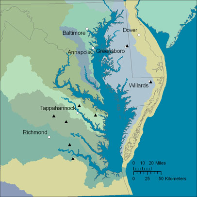
1) Survey stream channel geometry along stream reaches including USGS streamflow-gaging stations throughout the Coastal Plain physiographic province. Identify bankfull features that represent channel forming flows.
2) Develop regional channel geometry curves for the Coastal Plain province in Virginia using power functions to represent relations between drainage area and bankfull discharge, cross-sectional area, width, and average depth for stream riffle sections.
Relevance and Benefits
Properly developed regional curves for a specific hydro-physiographic province are an invaluable tool for stream restoration design. Development of regional curves specifically for physiographic provinces of Virginia will enhance the ability to develop successful natural channel designs based on climatic, geologic, and hydrologic characteristics of specific regions of the state.
Approach
Bankfull channel geometry data will be collected at up to 15 sites in the Coastal Plain province. A longitudinal profile of bankfull features for a length of 20 times the bankfull width of the channel will be surveyed for each site. The survey data collected includes at a minimum two riffle cross sections and a longitudinal profile of the stream. Bed material size is determined through a modified Wolman pebble count. This information will be used to classify the streams based on the Rosgen classification system and to develop regression relations between drainage area and bankfull width, depth, cross-sectional area, and discharge.
Presentations and Publications
Virginia
Stream Alliance presentation March 16, 2006 (PDF 0.9 MB)
|