

|
|
|
|
The Coastal
Plain province encompasses approximately 8,500 mi2
and is an eastward-thickening wedge of sediments composed principally of
unconsolidated gravels, sands, silts, and clays, with variable amounts of
shells. These unconsolidated deposits directly overlie bedrock that
slopes eastward and is commonly referred to as the basement.
The sediments attain a
 maximum thickness of over 6,000 ft in the
northeastern part of the Coastal Plain of Virginia. Onuschak (1972)
states that the sediments are 6,186 ft thick beneath the Eastern Shore Peninsula at
Temperanceville, Va.. Coastal Plain sediments thin westward and
effectively end at the Fall Line, which is where the Piedmont province
begins. maximum thickness of over 6,000 ft in the
northeastern part of the Coastal Plain of Virginia. Onuschak (1972)
states that the sediments are 6,186 ft thick beneath the Eastern Shore Peninsula at
Temperanceville, Va.. Coastal Plain sediments thin westward and
effectively end at the Fall Line, which is where the Piedmont province
begins.
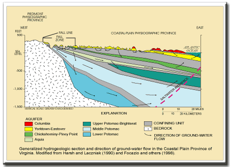
The Coastal Plain is subdivided into 7 aquifers separated by intervening confining units--silts and clays (Meng and Harsh, 1988). Generally, the Columbia aquifer and, in certain areas, the Yorktown-Eastover aquifer are unconfined and the deeper aquifers are confined, except in areas near the Fall Zone where these aquifers are exposed at the surface (McFarland, 1997). In the lower Chesapeake Bay, the structural and stratigraphic features created by the Chesapeake Bay impact crater have disrupted the "normal" aquifer system sequence and influenced the hydrogeology, ground-water flow system, and water quality in a large part of the Coastal Plain. The impact crater was was formed when a large comet or meteorite crashed into shallow shelf-depth waters of the western Atlantic Ocean approximately 35 million years ago. The crater is a 56-mile wide structure that penetrates the basement to a depth of at least 1.2 miles (Powars and Bruce, 1999; Powars, 2000). Ground-Water Flow Ground-water moves around and between sediment grains in the Coastal Plain. The tortuous path of water in the aquifers causes the residence times to be much larger than in the other provinces. Ground-water storage can be much larger in the Coastal Plain than in the other provinces. Nearly 100 Mgal/d (million gallons per day) are removed from the Coastal Plain aquifers by major ground-water users (Hammond and Focazio, 1995). Apparent ground-water ages can be relatively young in the shallow parts of the Coastal Plain where local flow systems are prevalent. In the deep parts of the Coastal Plain, ground-water moves slowly along sub-regional to regional flow paths. The apparent ground-water ages can be on the order of hundreds to thousands or more years. |
|
References Focazio, M.J., Plummer, L.N., Böhlke, J.K., Busenberg, Eurybiades, Bachman, L.J., and Powars, D.S., 1998, Preliminary estimates of residence times and apparent ages of ground water in the Chesapeake Bay Watershed, and water-quality data from a survey of springs: U.S. Geological Survey Water-Resources Investigations Report 97-4225, 75 p. Hammond, E.C., and Focazio, M.J., 1995, Water us in Virginia-Surface-water and ground-water withdrawals during 1992: U.S. Geological Survey Fact Sheet 94-057, 2 p. McFarland, E.R., 1997, Hydrogeologic framework, analysis of ground-water flow, and relations to regional flow in the Fall Zone near Richmond, Virginia: USGS Water-Resources Investigations Report 97-4021, 56 p. Meng, A.A., III, and Harsh, J.F., 1988, Hydrogeologic framework of the Virginia Coastal Plain: U.S. Geological Survey Professional Paper 1404-C, 82 p. Powars, D.S., 2000, The effects of the Chesapeake Bay impact crater on the geologic framework and the correlation of hydrogeologic units of southeastern Virginia, south of the James River: USGS Professional Paper 1622, 53 p., 1 pl. Powars, D.S., and Bruce, T. S., 1999, The effects of the Chesapeake Bay impact crater on the geological framework and correlation of hydrogeologic units of the lower York-James Peninsula, Virginia: USGS Professional Paper 1612, 82 p., 9 pl. Onuschak, E., Jr., 1972, Deep test in Accomack County, Virginia: Virginia Division of Mineral Resources, Virginia Minerals, v. 18, no. 1, p. 1-4.
|
|
|
|
|

|

|

|
|
|
| Last Updated on 2/4/2002 By David L. Nelms |
Contact: GS-W-VArmd_webmaster@usgs.gov
U.S. Department of Interior,
U.S. Geological Survey
Privacy Statement
Disclaimer
Accessibility
URL http://va.water.usgs.gov/va123/4strat-CP.html
Last update: 09/15/04 12:51