Virginia Water Science Center
|
DATA CENTER
USGS IN YOUR STATEUSGS Water Science Centers are located in each state.
|
Current Water-Resources Conditions in VirginiaThe U.S. Geological Survey (USGS) and the Virginia Department of Environmental Quality has a network of 261 real-time monitoring stations in Virginia. The network provides real-time water-stage data along with computed streamflow at 188 stations, water quality recorded at 114 stations, ground-water levels recorded at 61 stations, precipitation recorded at 6 stations, and reservoir level recorded at 3 stations. These sites continuously record data on 15-minute intervals and transmit the data via satellite to be incorporated into the USGS National Water Information System database. These data are automatically posted to the USGS NWISWeb site for public dissemination. Current Daily Streamflow Conditions
Surface-Water Drought Information
Current Ground-Water Conditions
Current Water Conditions for Warren Co.
Current Water Conditions for the Shenandoah Valley
|

![]() U.S. Department of the Interior
| U.S. Geological Survey
U.S. Department of the Interior
| U.S. Geological Survey
URL: http://va.water.usgs.gov/warren/current.htm
Page Contact Information: webmaster-va@usgs.gov
Page Last Modified: 18-Aug-2008 11:00:00 EDT


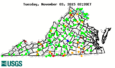
 The colored dots on this map depict streamflow conditions as a
percentile, which is computed from the period of record for the current
day of the year. Only stations with at least 30 years of record are used.
The gray circles indicate other stations that were not ranked in
percentiles either because they have fewer than 30 years of record or
because they report parameters other than streamflow. Some stations, for
example, measure stage only.
The colored dots on this map depict streamflow conditions as a
percentile, which is computed from the period of record for the current
day of the year. Only stations with at least 30 years of record are used.
The gray circles indicate other stations that were not ranked in
percentiles either because they have fewer than 30 years of record or
because they report parameters other than streamflow. Some stations, for
example, measure stage only. 
 The colored dots on this map depict
ground-water conditions as a
percentile, which is computed from the period of record for the current
month of the year. Only wells with at least 10 years of record are used.
The gray circles indicate other wells that were not ranked in
percentiles because they have fewer than 10 years of record.
The colored dots on this map depict
ground-water conditions as a
percentile, which is computed from the period of record for the current
month of the year. Only wells with at least 10 years of record are used.
The gray circles indicate other wells that were not ranked in
percentiles because they have fewer than 10 years of record. 
