|

DATA CENTER
|
Geophysical Data for Warren County, Virginia
| Borehole and surface geophysical data
have been collected in Warren County to provide insight
into the nature of fracturing, to aid in the development
of the hydrogeologic framework, and to investigate
ground water/surface water interactions. |
| |
|
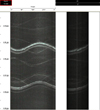 |
Borehole geophysical logging ( )--
Standard borehole logging methods (caliper, gamma,
single and multi-point resistance, self potential, fluid
temperature and resistivity) along with electromagnetic
(EM) induction, acoustic and optical televiewer,
borehole video camera, and borehole deviation are being
used to investigate hydrogeologic unit contacts,
fracturing, and water-bearing properties. )--
Standard borehole logging methods (caliper, gamma,
single and multi-point resistance, self potential, fluid
temperature and resistivity) along with electromagnetic
(EM) induction, acoustic and optical televiewer,
borehole video camera, and borehole deviation are being
used to investigate hydrogeologic unit contacts,
fracturing, and water-bearing properties. |
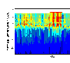 |
Surface geophysics ()-- Marine continuous resistivity and multi-frequency domain
electromagnetic have been measured along the South Fork
of the Shenandoah River and the Shenandoah River to
investigate ground water and surface water interactions. |
| Additional
information on geophysical techniques used in hydrologic
investigations is available at the U.S. Geological
Survey, Office of Ground Water, Branch of Geophysics (http://water.usgs.gov/ogw/bgas/) |
|
|