Integrated Assessment of the Northern Shenandoah Valley in Virginia and West Virginia
 >
>
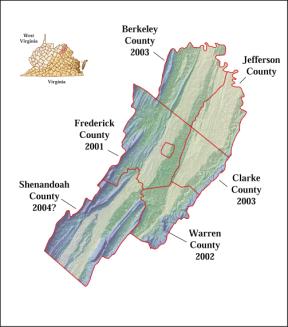
Figure 1. Map of the Northern Shenandoah Valley with start dates of county-scale cooperative ground-water assessments.
Statement of Problem
In recent years, the Northern Shenandoah Valley of Virginia and West Virginia has been experiencing rapid growth along the I-81 corridor and the eastern margin of the Valley. Increased development of these predominantly rural counties is expected to continue as new residents commute to the Washington, D.C. metropolitan area. This growth has the potential to profoundly influence the region’s land, water, and biological resources. Regional and local resource managers have real concerns over the region’s ability to sustain future growth. Current resource-management concerns center on the sustainability and vulnerability of the region’s water resources and their ability to provide a reliable long-term water supply.
The Northern Shenandoah Valley is underlain by karst and fractured-rock aquifers that are increasingly being relied upon to supply water to areas with a greater density of development. Conflicts among instream and offstream users of streamflow also have increased as flows decrease. The recent prolonged drought has focused attention in this region on the quantity and sustainability of the water resources. An improved understanding of the complex aquifer systems is required to effectively develop and manage them as sustainable water supplies and aquatic habitats. In order to assess current and future hydrologic conditions within the region, a long-term monitoring network needs to be designed and implemented, and a hydrogeologic framework needs to be developed to aid in the understanding of how water enters and moves through the aquifer system. Detailed geologic mapping along with fracture analyses, conduit analyses, and mapping of karst features will form this framework.
Furthermore, information provided by a detailed hydrogeologic appraisal will provide useful information to better address questions about (1) the quantity of water available for use, (2) the effects of increased withdrawals on ground-water levels and instream flows (habitat duration), (3) the relation between karst and fractured-rock features and the hydrology and geochemistry of the surface- and ground-water flow systems, (4) the delineation of areas prone to subsidence (sinkhole collapse) and slope stability hazards, and (5) the quality of the ground-water supply and its vulnerability to current and potential future sources of contamination.
As shown on the last page of this document, the USGS has several complementary investigations that are currently underway or planned for the Northern Shenandoah Valley. Each of these studies has a well defined purpose and scope of its own, yet each will yield important information that can contribute to integrated regional assessments of the Valley's land, water, and biological resources.
Objective
The objective of this first integrated regional assessment is to better characterize the aquifer systems in the Northern Shenandoah Valley and provide relevant hydrogeologic information that can be used to guide the development and management of these water resources. This regional study of the karst and fractured-rock aquifer systems will use hydrologic, geologic, cartographic, and biologic information to improve the understanding of the aquifer systems, their relationship to surface features, and potential hazards over a multi-county area of Virginia and West Virginia.
Relevance and Impact
Societal issues related to karst and fractured-rock aquifers have been increasing over the years in response to urban, industrial, agricultural, and residential development and associated ground-water contamination, ground-water availability, and subsidence hazards. Geologic mapping forms the foundation for a three-dimensional framework; whereby the integration of mapping and hydrogeologic studies at a regional scale will show how fractures, faults, and stratigraphy control both the occurrence and movement of ground water, and sinkhole and conduit development. Interdisciplinary research on topics related to the quantity, quality, sustainability, and habitat availability will be based on the regional framework and understanding of the water resources.
This project will contribute to the knowledge of water
resources in the Northern Shenandoah Valley and will set the framework for
further investigation of the fundamental processes controlling the occurrence
and movement of water in the karst and fractured-rock aquifer systems. Over the
long term, information from this study will increase our knowledge of the
hydrogeologic controls on ground-water flow in similar karst and fractured-rock
terrains of the Middle Atlantic States and will provide a record to assess
climatic and societal impacts on the region’s water resources in the future.
Strategy and Approach
This regional study will be conducted as a long-term
appraisal of the Northern Shenandoah Valley aquifer systems with two major
components: (1) long-term monitoring and (2) hydrogeologic assessment. The first component will consist of the
design and implementation of a long-term network to monitor ground-water
levels, streamflow, and spring discharge by recently initiated projects funded
by the Cooperative Water Program. The
second component will consist of a hydrogeologic assessment of the karst and
fractured-rock aquifer systems in the region, which will integrate research
activities from projects funded by the National Cooperative Geologic Mapping,
Land and Remote Sensing, Cooperative Water, and National Research
Programs. Major work elements of the
hydrogeologic assessment include: (1) hydrogeologic framework, (2) ground-water
flow system, (3) water budget, (4) water quality (including aquifer susceptibility),
(5) geographic information system coverages, and (6) information assessment and
outreach.
Detailed geologic maps will be produced for selected areas underlain by the karst and fractured-rock aquifers. The hydrogeologic framework will be determined through geologic mapping, fracture analysis, conduit analysis, and a karst inventory. To aid in the karst inventory and geologic analyses of karst features in the Shenandoah Valley, unique remote-sensing data from the National Technical Means will be used to locate karst features. Maps of these karst features will be analyzed with the geologic maps to evaluate geologic controls on karst development. In turn, karst hazards maps will be produced as derivatives. This geologic information will then be compiled with the water-resources information to assess geologic controls on ground-water movement, availability, and quality.
The current focus of this interdisciplinary investigation will center on the sustainability of the region’s ground-water resources. It is anticipated that as demands for water resources continue, the focus of this work will expand to a Shenandoah River Basin-wide assessment of the region’s water and aquatic biological resources This assessment will serve as a model for application to other areas of the Great Valley. The regional assessment may further be expanded to include an evaluation of the hazards of expanding the regional transportation network over karts terrain, the preservation and restoration of riparian corridors, and other issues of regional concern.
Current USGS Program Activities in the Northern Shenandoah Valley
National Cooperative Geologic Mapping Program
· Karst Applied Research Studies Project (KARST)
· Bedrock Regional Aquifer Systematics Study (BRASS)
National Landslide Hazards Program
· Debris-Flow Hazards in the Blue Ridge of Virginia
Land and Remote Sensing Program
· National Civil Applications Project (NCAP) - mapping of karst features
Cooperative Water Program
Virginia
· North Fork Shenandoah River Instream Flow Study
· Frederick County Carbonate Aquifer Appraisal
· Clarke County Aquifer Appraisal
· Warren County Siliciclastic and Crystalline Aquifers Appraisal
West Virginia
· Berkeley County Karst Aquifer Appraisal
Federal Program
· Leetown Science Center, W. Va. Karst Aquifer Assessment
National Research Program (NRP)
Kinetic Modeling (Ground-Water Age Dating)
· Shenandoah National Park
· Karst Springs
Transport Phenomena in Fractured Rock
· Leetown Science Center
National Water-Quality Assessment (NAWQA) Program
· Potomac-Delmarva (PODL) Study Unit
Biological Informatics Program
· Shenandoah NBII node - proposed