Develop Estimates of Hydrologic Budget Components
Quantifying the magnitude and distribution of limited fresh groundwater supplies in the Appalachian Plateaus requires that estimates of hydrologic budget components be developed based on compilation, refinement, and integration of existing local-scale water budgets from mass balance and regression analyses and available water-use and climatic data.
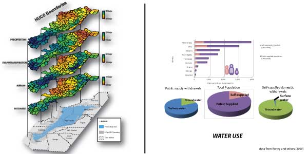
A hydrologic budget will be developed for historical and current conditions for the Appalachian Plateau aquifers. A regional hydrologic budget analysis provides for an essential understanding of water uses in context of the overall fluxes in the system.
Precipitation falling on the Plateaus is ultimately consumed by evapotranspiration, groundwater recharge, and runoff to streams. Direct runoff to streams accounts for 17 to 20 percent of annual precipitation in the Appalachian Plateaus (Zurawski, 1978). Evapotranspiration accounts for an estimated 52 percent of total precipitation in this region (Fleeger, 1999), ranging from 21 in/yr (Mohamoud, 2004) to 29 in/yr (Zuwarksi, 1978). Recharge occurs primarily in topographically high areas (ridges) and flows laterally and downward through shallow fractures in the bedrock (Harlow and LeCain, 1993). Recharge to Plateaus aquifers typically ranges from 6 to 18 in/yr (Reese and Risser, 2010; Dumouchelle and Schiefer, 2002; Zurawski, 1978).
Recharge discharges as base flow to local streams and rivers with generally negligible changes in groundwater storage through time, although deep mining and subsequent filling of abandoned mine workings with groundwater temporally affects groundwater storage. Higher rates of apparent recharge in mined basins range from 21 to 25 in/yr and support concepts of enhanced permeability associated with coal extraction (Kozar and Mathes, 2001). Groundwater discharge from dissected uplands accounts for 50 to 65 percent of streamflow in Pennsylvania (Fleeger, 1999), the Ohio River Basin (Bloyd, 1974), and the Tennessee River Basin (Zurawski, 1978).
See Also
For more information on the USGS Regional Groundwater Studies, please visit the USGS Groundwater Resources Program.