|
|
||
| Determination of Streamflow Conditions |
| For each streamgage: | |||||||||||||||||||||||||||||||||||||||||||||||||||||||||||||||||||||||||||||||||||||||||||||||||||||||||||||||||||||||||||||||||||||||||||||||||||||||||||||||||||||||||||||||||||||||||||||||||||||||||||||||||||||||||||||||||||||||||||||||||||||||||||||||||||||||||||||||||||||||||||||||
| 1. |
The daily average streamflow value is compared to all historical daily average streamflow values grouped by month of the year. All the daily average flow values for each month are arranged according to magnitude from lowest to highest. From the data, the 5th, 10th, 25th, 50th, 75th, 90th, and 95th, percentiles are determined as well as the minimum and maximum streamflow values. The percentile of the current daily average streamflow value is its "position" relative to the other values in the sorted dataset and rescaled to range between 0 and 100. Streamflow conditions are not determined for streamgages where the flow is highly regulated or current data is missing. |
||||||||||||||||||||||||||||||||||||||||||||||||||||||||||||||||||||||||||||||||||||||||||||||||||||||||||||||||||||||||||||||||||||||||||||||||||||||||||||||||||||||||||||||||||||||||||||||||||||||||||||||||||||||||||||||||||||||||||||||||||||||||||||||||||||||||||||||||||||||||||||||
| For each hydrologic unit: | |||||||||||||||||||||||||||||||||||||||||||||||||||||||||||||||||||||||||||||||||||||||||||||||||||||||||||||||||||||||||||||||||||||||||||||||||||||||||||||||||||||||||||||||||||||||||||||||||||||||||||||||||||||||||||||||||||||||||||||||||||||||||||||||||||||||||||||||||||||||||||||||
| 2. |
A median of the
daily average streamflow percentiles (from step 1) is computed
for each eight digit hydrologic cataloging unit. The median
value is derived using data from all unregulated streamgages
where the drainage basins are contained entirely within the
hydrologic cataloging unit. Streamgages where the current flow
is regulated, the drainage basin incorporates area from more
than one hydrologic cataloging unit, or the current daily
average streamflow is missing are not used in computation of the
median value. |
||||||||||||||||||||||||||||||||||||||||||||||||||||||||||||||||||||||||||||||||||||||||||||||||||||||||||||||||||||||||||||||||||||||||||||||||||||||||||||||||||||||||||||||||||||||||||||||||||||||||||||||||||||||||||||||||||||||||||||||||||||||||||||||||||||||||||||||||||||||||||||||
|
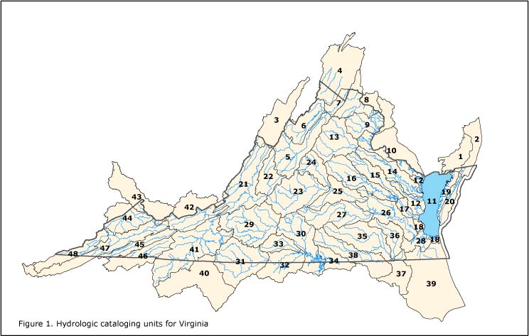
Hydrologic Units A hydrologic unit is a geographic area representing part or all of a surface drainage basin or distinct hydrologic feature as delineated by the Office of Water Data Coordination on State Hydrologic Unit Maps. The United States is divided and sub-divided into successively smaller hydrologic units which are classified into four levels: regions, sub-regions, accounting units, and cataloging units. The hydrologic units are arranged within each other, from the smallest (cataloging units) to the largest (regions). Each hydrologic unit is identified by a unique hydrologic unit code (HUC) consisting of two (regions) to eight (cataloging units) digits based on the four levels of classification in the hydrologic unit system. The first level of classification divides the Nation into 21 major geographic areas, or regions. These geographic areas contain either the drainage area of a major river, such as the Missouri region, or the combined drainage areas of a series of rivers, such as the Texas-Gulf region, which includes a number of rivers draining into the Gulf of Mexico. Eighteen of the regions occupy the land area of the conterminous United States. Alaska is region 19, the Hawaii Islands constitute region 20, and Puerto Rico and other outlying Caribbean areas are region 21. The second level of classification divides the 21 regions into 221 subregions. A subregion includes the area drained by a river system, a reach of a river and its tributaries in that reach, a closed basin(s), or a group of streams forming a coastal drainage area. The third level of classification subdivides many of the subregionsinto accounting units. These 378 hydrologic accounting units are nested within, or can be equivalent to the subregions. The fourth level of classification is the cataloging unit, the smallest element in the hierarchy of hydrologic units. [Efforts are underway to add further levels (5th and 6th levels) of subdivisions. A cataloging unit is a geographic area representing part of all of a surface drainage basin, a combination of drainage basins, or a distinct hydrologic feature. These units subdivide the subregions and accounting units into smaller areas. There are 2264 Cataloging Units in the Nation. Cataloging Units sometimes are called "watersheds." Figure 1 shows the hydrologic cataloging units for Virginia. The table list the unit numbers, hydrologic unit names, and stations used to determine flow statistics for each hydrologic unit. |
|||||||||||||||||||||||||||||||||||||||||||||||||||||||||||||||||||||||||||||||||||||||||||||||||||||||||||||||||||||||||||||||||||||||||||||||||||||||||||||||||||||||||||||||||||||||||||||||||||||||||||||||||||||||||||||||||||||||||||||||||||||||||||||||||||||||||||||||||||||||||||||||
 |
|||||||||||||||||||||||||||||||||||||||||||||||||||||||||||||||||||||||||||||||||||||||||||||||||||||||||||||||||||||||||||||||||||||||||||||||||||||||||||||||||||||||||||||||||||||||||||||||||||||||||||||||||||||||||||||||||||||||||||||||||||||||||||||||||||||||||||||||||||||||||||||||
|
|||||||||||||||||||||||||||||||||||||||||||||||||||||||||||||||||||||||||||||||||||||||||||||||||||||||||||||||||||||||||||||||||||||||||||||||||||||||||||||||||||||||||||||||||||||||||||||||||||||||||||||||||||||||||||||||||||||||||||||||||||||||||||||||||||||||||||||||||||||||||||||||