|
01622000
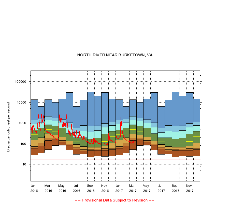
NORTH RIVER NEAR BURKETOWN, VA
|
Minimum daily flow
|
|
|
5th percentile
|
|
|
|
10th percentile
|
|
|
|
|
25th percentile
|
|
|
|
|
|
Median
|
|
|
|
|
|
|
75th percentile
|
|
|
|
|
|
|
|
90th percentile
|
|
|
|
|
|
|
|
|
95th percentile
|
|
|
|
|
|
|
|
|
|
Maximum daily flow
|
|
|
|
|
|
|
|
|
|
|
|
Years of record
|
January
|
28.0
|
59.0
|
72.0
|
148
|
270
|
473
|
878
|
1,370
|
13,700
|
|
86
|
February
|
35.0
|
78.0
|
109
|
194
|
323
|
584
|
1,020
|
1,520
|
6,230
|
|
86
|
March
|
52.0
|
142
|
186
|
293
|
478
|
820
|
1,400
|
2,080
|
13,600
|
|
86
|
April
|
80.0
|
154
|
188
|
260
|
398
|
712
|
1,260
|
1,790
|
10,000
|
|
86
|
May
|
84.0
|
119
|
144
|
211
|
328
|
567
|
1,010
|
1,460
|
14,500
|
|
86
|
June
|
49.0
|
83.0
|
97.0
|
130
|
182
|
307
|
627
|
1,040
|
29,900
|
|
88
|
July
|
30.0
|
55.0
|
67.0
|
90.0
|
124
|
193
|
347
|
565
|
6,300
|
|
88
|
August
|
32.0
|
44.0
|
52.0
|
72.0
|
105
|
194
|
412
|
760
|
12,700
|
|
88
|
September
|
22.0
|
46.0
|
53.0
|
67.0
|
95.0
|
171
|
378
|
687
|
32,000
|
|
88
|
October
|
25.0
|
48.0
|
54.0
|
66.5
|
99.0
|
190
|
427
|
745
|
20,100
|
|
87
|
November
|
24.0
|
48.0
|
57.1
|
76.0
|
127
|
294
|
625
|
950
|
30,000
|
|
86
|
December
|
25.0
|
52.0
|
60.0
|
108
|
225
|
400
|
766
|
1,140
|
14,800
|
|
86
|
|
|
Instantaneous minimum flow for period of record =
16.0
cubic feet per second.
The current daily value for 03/22/2017 is 151.0 cubic feet per second.
----
Provisional Data Subject to Revision ----
|