|
01625000
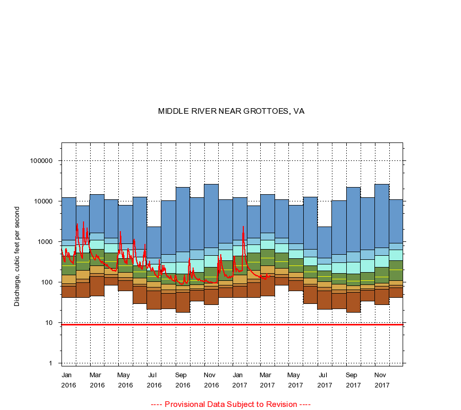
MIDDLE RIVER NEAR GROTTOES, VA
|
Minimum daily flow
|
|
|
5th percentile
|
|
|
|
10th percentile
|
|
|
|
|
25th percentile
|
|
|
|
|
|
Median
|
|
|
|
|
|
|
75th percentile
|
|
|
|
|
|
|
|
90th percentile
|
|
|
|
|
|
|
|
|
95th percentile
|
|
|
|
|
|
|
|
|
|
Maximum daily flow
|
|
|
|
|
|
|
|
|
|
|
|
Years of record
|
January
|
42.0
|
78.0
|
91.0
|
150
|
250
|
435
|
800
|
1,100
|
12,400
|
|
88
|
February
|
42.0
|
97.0
|
120
|
193
|
308
|
518
|
839
|
1,230
|
7,710
|
|
88
|
March
|
45.0
|
136
|
166
|
254
|
388
|
650
|
1,100
|
1,650
|
14,600
|
|
88
|
April
|
83.0
|
130
|
156
|
216
|
318
|
523
|
886
|
1,230
|
10,800
|
|
88
|
May
|
61.0
|
109
|
129
|
175
|
256
|
384
|
617
|
877
|
7,840
|
|
88
|
June
|
29.0
|
78.0
|
90.0
|
127
|
178
|
257
|
412
|
650
|
12,700
|
|
88
|
July
|
21.0
|
61.0
|
74.0
|
102
|
138
|
188
|
278
|
390
|
2,300
|
|
88
|
August
|
22.0
|
53.0
|
65.0
|
89.0
|
118
|
163
|
303
|
476
|
10,300
|
|
88
|
September
|
18.0
|
56.0
|
64.0
|
81.0
|
107
|
159
|
307
|
552
|
21,700
|
|
88
|
October
|
34.0
|
62.0
|
68.0
|
86.0
|
109
|
175
|
362
|
618
|
12,100
|
|
88
|
November
|
28.0
|
67.0
|
78.0
|
94.0
|
132
|
232
|
450
|
709
|
26,000
|
|
88
|
December
|
41.0
|
72.0
|
83.0
|
110
|
200
|
339
|
625
|
914
|
11,000
|
|
88
|
|
|
Instantaneous minimum flow for period of record =
8.90
cubic feet per second.
The current daily value for 03/22/2017 is 143.0 cubic feet per second.
----
Provisional Data Subject to Revision ----
|