|
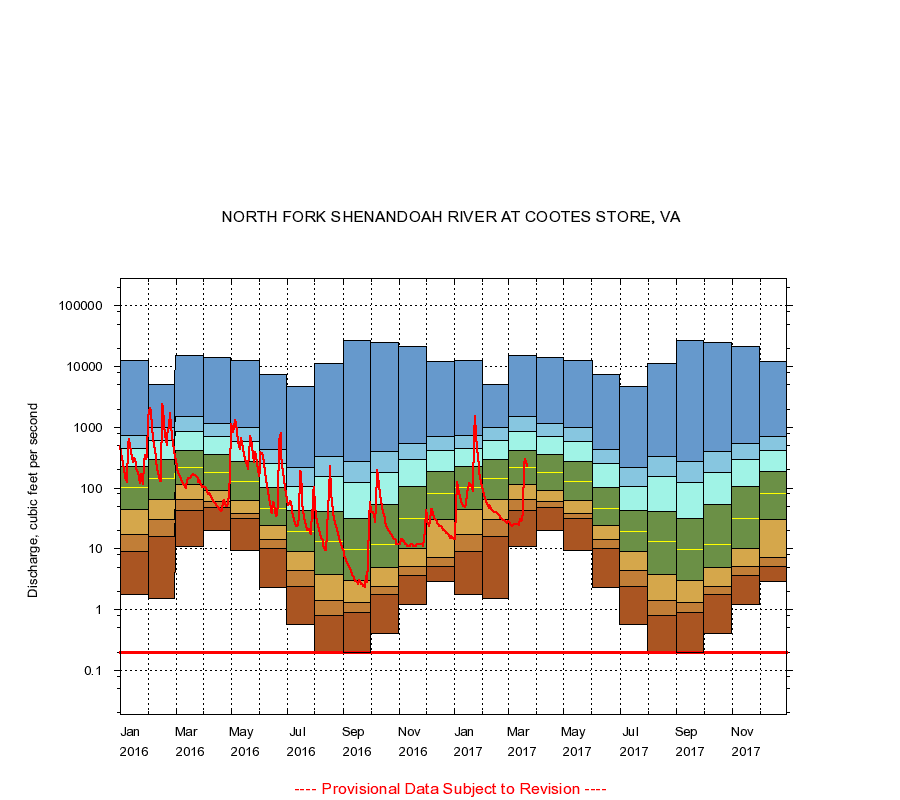
01632000
NORTH FORK SHENANDOAH RIVER AT COOTES STORE, VA
|
Minimum daily flow
|
|
|
5th percentile
|
|
|
|
10th percentile
|
|
|
|
|
25th percentile
|
|
|
|
|
|
Median
|
|
|
|
|
|
|
75th percentile
|
|
|
|
|
|
|
|
90th percentile
|
|
|
|
|
|
|
|
|
95th percentile
|
|
|
|
|
|
|
|
|
|
Maximum daily flow
|
|
|
|
|
|
|
|
|
|
|
|
Years of record
|
January
|
1.80
|
9.20
|
17.0
|
45.0
|
102
|
228
|
444
|
722
|
12,800
|
|
90
|
February
|
1.50
|
16.0
|
30.0
|
65.0
|
142
|
290
|
611
|
1,000
|
5,140
|
|
90
|
March
|
11.0
|
42.0
|
66.0
|
116
|
217
|
414
|
861
|
1,480
|
14,900
|
|
90
|
April
|
20.0
|
48.0
|
60.0
|
92.0
|
180
|
360
|
712
|
1,160
|
13,900
|
|
91
|
May
|
9.40
|
31.0
|
38.0
|
63.0
|
126
|
275
|
578
|
1,010
|
12,500
|
|
91
|
June
|
2.30
|
10.0
|
14.0
|
24.0
|
46.0
|
104
|
257
|
437
|
7,390
|
|
91
|
July
|
0.57
|
2.40
|
4.40
|
9.10
|
19.0
|
43.0
|
108
|
220
|
4,770
|
|
91
|
August
|
0.20
|
0.80
|
1.40
|
3.80
|
13.0
|
41.0
|
155
|
327
|
11,400
|
|
91
|
September
|
0.20
|
0.90
|
1.30
|
3.00
|
9.80
|
32.0
|
123
|
273
|
26,400
|
|
91
|
October
|
0.40
|
1.80
|
2.40
|
5.00
|
12.0
|
54.0
|
179
|
402
|
24,900
|
|
90
|
November
|
1.20
|
3.70
|
5.20
|
10.0
|
32.0
|
108
|
300
|
550
|
21,000
|
|
90
|
December
|
2.90
|
5.20
|
7.20
|
30.0
|
82.0
|
188
|
414
|
700
|
12,100
|
|
90
|
|
|
Instantaneous minimum flow for period of record =
0.20
cubic feet per second.
The current daily value for 03/22/2017 is 226.0 cubic feet per second.
----
Provisional Data Subject to Revision ----
|