|
01634500
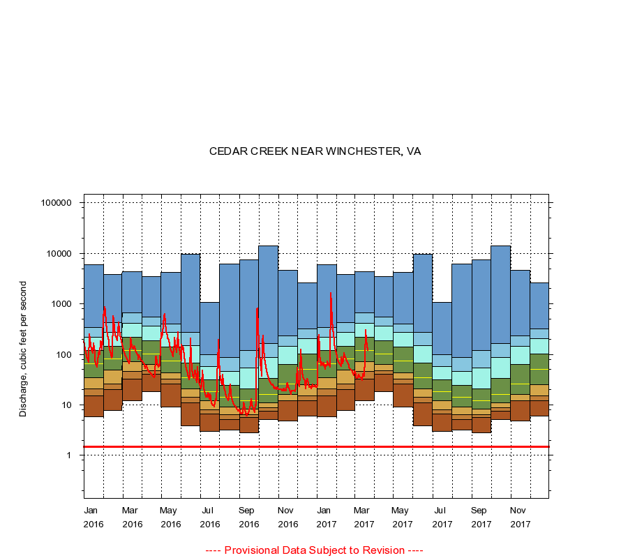
CEDAR CREEK NEAR WINCHESTER, VA
|
Minimum daily flow
|
|
|
5th percentile
|
|
|
|
10th percentile
|
|
|
|
|
25th percentile
|
|
|
|
|
|
Median
|
|
|
|
|
|
|
75th percentile
|
|
|
|
|
|
|
|
90th percentile
|
|
|
|
|
|
|
|
|
95th percentile
|
|
|
|
|
|
|
|
|
|
Maximum daily flow
|
|
|
|
|
|
|
|
|
|
|
|
Years of record
|
January
|
5.80
|
15.0
|
20.9
|
34.0
|
65.0
|
120
|
219
|
337
|
6,000
|
|
78
|
February
|
7.80
|
20.0
|
26.0
|
49.0
|
82.0
|
143
|
276
|
432
|
3,770
|
|
78
|
March
|
12.0
|
32.0
|
46.0
|
71.0
|
121
|
218
|
408
|
660
|
4,280
|
|
78
|
April
|
18.0
|
40.0
|
47.0
|
64.0
|
103
|
187
|
360
|
541
|
3,420
|
|
78
|
May
|
9.10
|
26.0
|
32.0
|
43.0
|
75.0
|
140
|
276
|
402
|
4,260
|
|
78
|
June
|
3.80
|
11.0
|
14.0
|
21.0
|
35.0
|
67.0
|
150
|
269
|
9,500
|
|
78
|
July
|
3.00
|
6.60
|
8.00
|
12.0
|
18.0
|
31.0
|
58.0
|
98.0
|
1,070
|
|
78
|
August
|
3.20
|
5.20
|
6.40
|
9.20
|
14.0
|
24.0
|
46.0
|
87.0
|
6,060
|
|
78
|
September
|
2.80
|
5.60
|
6.40
|
8.20
|
12.0
|
21.0
|
53.9
|
120
|
7,400
|
|
78
|
October
|
5.20
|
7.40
|
8.69
|
11.0
|
16.0
|
33.2
|
86.1
|
162
|
13,900
|
|
78
|
November
|
4.80
|
12.0
|
12.0
|
16.0
|
26.0
|
63.0
|
145
|
233
|
4,580
|
|
78
|
December
|
6.00
|
12.0
|
15.0
|
25.0
|
50.0
|
101
|
205
|
315
|
2,580
|
|
78
|
|
|
Instantaneous minimum flow for period of record =
1.50
cubic feet per second.
The current daily value for 03/22/2017 is 121.0 cubic feet per second.
----
Provisional Data Subject to Revision ----
|