|
01638480
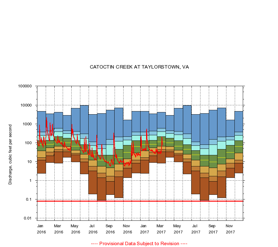
CATOCTIN CREEK AT TAYLORSTOWN, VA
|
Minimum daily flow
|
|
|
5th percentile
|
|
|
|
10th percentile
|
|
|
|
|
25th percentile
|
|
|
|
|
|
Median
|
|
|
|
|
|
|
75th percentile
|
|
|
|
|
|
|
|
90th percentile
|
|
|
|
|
|
|
|
|
95th percentile
|
|
|
|
|
|
|
|
|
|
Maximum daily flow
|
|
|
|
|
|
|
|
|
|
|
|
Years of record
|
January
|
2.40
|
12.0
|
16.0
|
38.0
|
79.0
|
128
|
242
|
367
|
4,660
|
|
44
|
February
|
8.90
|
20.2
|
32.0
|
55.0
|
82.0
|
136
|
258
|
416
|
3,400
|
|
44
|
March
|
8.40
|
33.2
|
44.0
|
66.0
|
113
|
210
|
380
|
583
|
4,160
|
|
44
|
April
|
17.0
|
33.0
|
42.0
|
63.0
|
99.0
|
178
|
308
|
428
|
2,810
|
|
44
|
May
|
9.50
|
23.0
|
28.0
|
40.0
|
65.0
|
131
|
260
|
393
|
6,770
|
|
44
|
June
|
2.20
|
9.50
|
14.0
|
25.0
|
45.5
|
80.0
|
166
|
297
|
9,530
|
|
44
|
July
|
0.19
|
3.20
|
5.75
|
12.0
|
23.0
|
39.0
|
70.0
|
110
|
3,190
|
|
44
|
August
|
0.09
|
1.40
|
2.50
|
5.60
|
12.0
|
22.0
|
49.0
|
79.2
|
3,500
|
|
45
|
September
|
0.18
|
0.89
|
1.70
|
4.70
|
9.65
|
22.0
|
79.9
|
153
|
5,400
|
|
45
|
October
|
0.12
|
1.60
|
3.20
|
7.40
|
16.0
|
45.0
|
121
|
205
|
7,040
|
|
44
|
November
|
1.40
|
4.60
|
8.20
|
14.0
|
31.0
|
73.0
|
140
|
214
|
1,620
|
|
44
|
December
|
2.50
|
8.40
|
12.0
|
29.0
|
64.0
|
127
|
247
|
378
|
4,580
|
|
44
|
|
|
Instantaneous minimum flow for period of record =
0.08
cubic feet per second.
The current daily value for 03/22/2017 is 73.0 cubic feet per second.
----
Provisional Data Subject to Revision ----
|