|
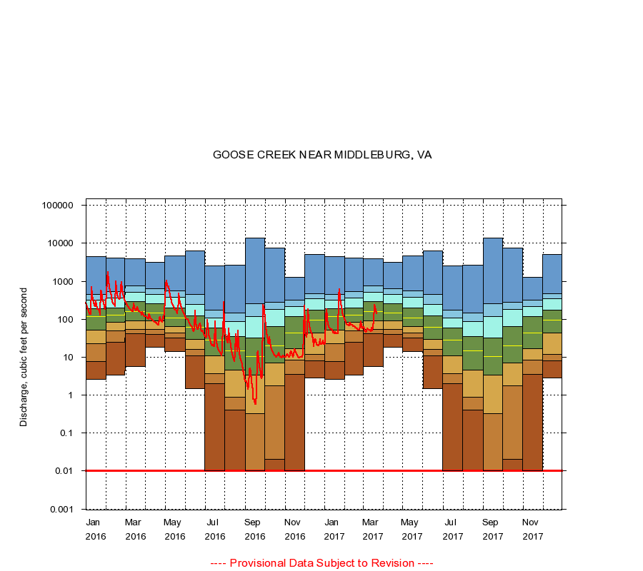
01643700
GOOSE CREEK NEAR MIDDLEBURG, VA
|
Minimum daily flow
|
|
|
5th percentile
|
|
|
|
10th percentile
|
|
|
|
|
25th percentile
|
|
|
|
|
|
Median
|
|
|
|
|
|
|
75th percentile
|
|
|
|
|
|
|
|
90th percentile
|
|
|
|
|
|
|
|
|
95th percentile
|
|
|
|
|
|
|
|
|
|
Maximum daily flow
|
|
|
|
|
|
|
|
|
|
|
|
Years of record
|
January
|
2.60
|
7.84
|
23.0
|
52.0
|
115
|
192
|
324
|
441
|
4,380
|
|
43
|
February
|
3.30
|
25.0
|
49.0
|
83.0
|
128
|
198
|
357
|
527
|
4,160
|
|
43
|
March
|
5.60
|
41.0
|
54.0
|
92.0
|
160
|
286
|
510
|
754
|
3,920
|
|
43
|
April
|
18.0
|
39.0
|
53.0
|
89.0
|
147
|
255
|
441
|
626
|
3,130
|
|
43
|
May
|
14.0
|
31.7
|
43.0
|
64.0
|
110
|
195
|
373
|
552
|
4,600
|
|
43
|
June
|
1.50
|
11.0
|
16.0
|
29.0
|
61.0
|
121
|
247
|
443
|
6,270
|
|
43
|
July
|
0.01
|
2.00
|
3.60
|
11.0
|
28.0
|
58.0
|
107
|
174
|
2,590
|
|
45
|
August
|
0.01
|
0.40
|
0.88
|
4.50
|
15.0
|
35.0
|
86.4
|
148
|
2,680
|
|
45
|
September
|
0.00
|
0.01
|
0.33
|
3.30
|
10.5
|
32.0
|
120
|
254
|
14,000
|
|
45
|
October
|
0.00
|
0.02
|
1.75
|
7.00
|
20.0
|
64.0
|
185
|
281
|
7,500
|
|
44
|
November
|
0.00
|
3.52
|
8.20
|
17.0
|
43.0
|
118
|
219
|
321
|
1,260
|
|
44
|
December
|
2.80
|
7.90
|
12.0
|
43.0
|
95.0
|
173
|
341
|
466
|
5,190
|
|
44
|
|
|
Instantaneous minimum flow for period of record =
0.00
cubic feet per second.
Flow values of 0.00 are plotted as 0.01
The current daily value for 03/22/2017 is 137.0 cubic feet per second.
----
Provisional Data Subject to Revision ----
|