|
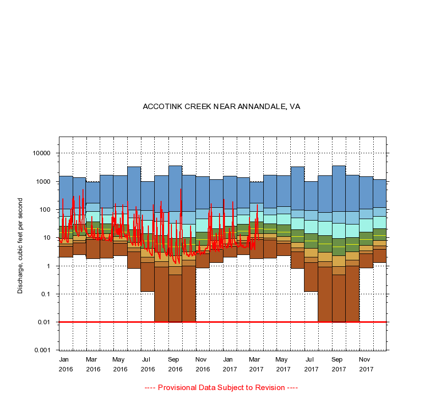
01654000
ACCOTINK CREEK NEAR ANNANDALE, VA
|
Minimum daily flow
|
|
|
5th percentile
|
|
|
|
10th percentile
|
|
|
|
|
25th percentile
|
|
|
|
|
|
Median
|
|
|
|
|
|
|
75th percentile
|
|
|
|
|
|
|
|
90th percentile
|
|
|
|
|
|
|
|
|
95th percentile
|
|
|
|
|
|
|
|
|
|
Maximum daily flow
|
|
|
|
|
|
|
|
|
|
|
|
Years of record
|
January
|
2.00
|
4.90
|
6.00
|
9.40
|
15.0
|
25.0
|
58.0
|
104
|
1,550
|
|
68
|
February
|
2.50
|
6.40
|
7.80
|
12.0
|
17.0
|
29.5
|
63.0
|
114
|
1,340
|
|
68
|
March
|
1.80
|
8.50
|
10.0
|
14.0
|
21.0
|
36.0
|
85.0
|
166
|
936
|
|
68
|
April
|
1.90
|
8.20
|
9.90
|
14.0
|
20.0
|
31.0
|
64.0
|
112
|
1,640
|
|
68
|
May
|
2.30
|
6.30
|
7.50
|
11.0
|
16.0
|
29.0
|
70.0
|
126
|
1,570
|
|
68
|
June
|
0.82
|
3.10
|
4.40
|
6.90
|
11.0
|
19.0
|
50.0
|
95.9
|
3,300
|
|
68
|
July
|
0.12
|
1.30
|
2.00
|
4.20
|
7.60
|
14.0
|
41.0
|
90.5
|
980
|
|
68
|
August
|
0.00
|
0.90
|
1.40
|
3.00
|
6.10
|
12.0
|
38.1
|
79.0
|
1,580
|
|
68
|
September
|
0.01
|
0.47
|
0.95
|
2.30
|
4.70
|
9.40
|
31.9
|
84.9
|
3,600
|
|
68
|
October
|
0.00
|
0.99
|
1.60
|
3.20
|
5.80
|
10.0
|
30.1
|
83.5
|
1,660
|
|
68
|
November
|
0.85
|
2.70
|
3.40
|
5.30
|
8.65
|
16.0
|
46.0
|
106
|
1,500
|
|
68
|
December
|
1.30
|
3.90
|
5.20
|
8.00
|
12.0
|
21.0
|
56.0
|
119
|
1,160
|
|
68
|
|
|
Instantaneous minimum flow for period of record =
0.00
cubic feet per second.
Flow values of 0.00 are plotted as 0.01
The current daily value for 03/22/2017 is 7.9 cubic feet per second.
----
Provisional Data Subject to Revision ----
|