|
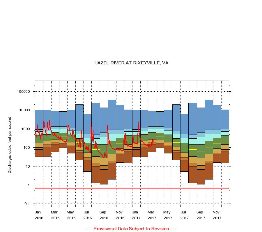
01663500
HAZEL RIVER AT RIXEYVILLE, VA
|
Minimum daily flow
|
|
|
5th percentile
|
|
|
|
10th percentile
|
|
|
|
|
25th percentile
|
|
|
|
|
|
Median
|
|
|
|
|
|
|
75th percentile
|
|
|
|
|
|
|
|
90th percentile
|
|
|
|
|
|
|
|
|
95th percentile
|
|
|
|
|
|
|
|
|
|
Maximum daily flow
|
|
|
|
|
|
|
|
|
|
|
|
Years of record
|
January
|
33.0
|
80.0
|
100
|
178
|
286
|
453
|
712
|
939
|
9,940
|
|
64
|
February
|
32.0
|
106
|
149
|
220
|
333
|
499
|
771
|
1,100
|
10,200
|
|
64
|
March
|
60.0
|
151
|
193
|
280
|
407
|
646
|
980
|
1,340
|
8,760
|
|
64
|
April
|
98.0
|
160
|
182
|
250
|
380
|
609
|
968
|
1,340
|
8,350
|
|
64
|
May
|
50.0
|
121
|
142
|
196
|
316
|
490
|
833
|
1,090
|
10,100
|
|
64
|
June
|
22.0
|
54.0
|
72.0
|
115
|
189
|
302
|
528
|
769
|
19,800
|
|
64
|
July
|
5.30
|
21.0
|
30.0
|
54.0
|
107
|
181
|
332
|
538
|
6,310
|
|
64
|
August
|
1.30
|
10.0
|
15.0
|
34.0
|
80.0
|
145
|
310
|
480
|
23,800
|
|
65
|
September
|
1.10
|
6.80
|
11.1
|
28.0
|
63.0
|
144
|
371
|
641
|
13,300
|
|
65
|
October
|
2.00
|
15.0
|
20.0
|
45.0
|
99.5
|
232
|
531
|
893
|
34,600
|
|
64
|
November
|
16.0
|
42.0
|
52.1
|
87.0
|
162
|
316
|
586
|
906
|
18,500
|
|
64
|
December
|
15.0
|
64.0
|
80.0
|
143
|
252
|
430
|
716
|
1,010
|
10,400
|
|
64
|
|
|
Instantaneous minimum flow for period of record =
0.70
cubic feet per second.
The current daily value for 03/22/2017 is 193.0 cubic feet per second.
----
Provisional Data Subject to Revision ----
|