|
01669520
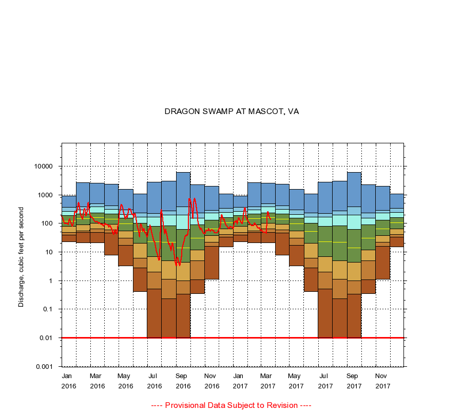
DRAGON SWAMP AT MASCOT, VA
|
Minimum daily flow
|
|
|
5th percentile
|
|
|
|
10th percentile
|
|
|
|
|
25th percentile
|
|
|
|
|
|
Median
|
|
|
|
|
|
|
75th percentile
|
|
|
|
|
|
|
|
90th percentile
|
|
|
|
|
|
|
|
|
95th percentile
|
|
|
|
|
|
|
|
|
|
Maximum daily flow
|
|
|
|
|
|
|
|
|
|
|
|
Years of record
|
January
|
23.0
|
39.0
|
49.0
|
84.8
|
123
|
188
|
265
|
361
|
910
|
|
24
|
February
|
21.0
|
42.8
|
58.0
|
97.0
|
162
|
230
|
314
|
400
|
2,690
|
|
22
|
March
|
21.0
|
51.0
|
67.3
|
109
|
172
|
255
|
392
|
524
|
2,530
|
|
24
|
April
|
7.70
|
43.0
|
61.0
|
96.8
|
146
|
239
|
349
|
456
|
2,380
|
|
24
|
May
|
3.30
|
15.0
|
25.0
|
54.8
|
107
|
165
|
224
|
298
|
1,570
|
|
24
|
June
|
0.41
|
2.10
|
5.99
|
21.8
|
58.0
|
104
|
172
|
250
|
1,070
|
|
24
|
July
|
0.00
|
0.39
|
1.63
|
6.78
|
30.0
|
87.5
|
173
|
234
|
2,800
|
|
24
|
August
|
0.00
|
0.16
|
0.88
|
5.72
|
25.0
|
99.8
|
220
|
344
|
1,500
|
|
25
|
September
|
0.04
|
0.47
|
0.96
|
3.80
|
13.0
|
59.8
|
184
|
354
|
6,050
|
|
25
|
October
|
0.35
|
0.78
|
4.29
|
13.8
|
32.0
|
85.0
|
152
|
220
|
734
|
|
24
|
November
|
1.10
|
14.0
|
21.0
|
40.0
|
67.5
|
124
|
210
|
278
|
749
|
|
24
|
December
|
15.0
|
32.0
|
41.0
|
64.0
|
101
|
160
|
246
|
316
|
678
|
|
24
|
|
|
Instantaneous minimum flow for period of record =
0.00
cubic feet per second
Flow values of 0.00 are plotted as 0.01
----
Provisional Data Subject to Revision ----
|