|
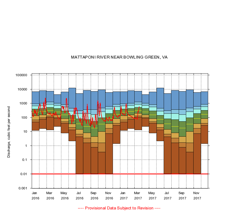
01674000
MATTAPONI RIVER NEAR BOWLING GREEN, VA
|
Minimum daily flow
|
|
|
5th percentile
|
|
|
|
10th percentile
|
|
|
|
|
25th percentile
|
|
|
|
|
|
Median
|
|
|
|
|
|
|
75th percentile
|
|
|
|
|
|
|
|
90th percentile
|
|
|
|
|
|
|
|
|
95th percentile
|
|
|
|
|
|
|
|
|
|
Maximum daily flow
|
|
|
|
|
|
|
|
|
|
|
|
Years of record
|
January
|
12.0
|
48.0
|
67.0
|
131
|
232
|
390
|
663
|
933
|
6,680
|
|
73
|
February
|
16.0
|
72.0
|
96.0
|
155
|
264
|
428
|
707
|
1,020
|
8,060
|
|
73
|
March
|
13.0
|
103
|
130
|
193
|
306
|
508
|
860
|
1,230
|
7,170
|
|
73
|
April
|
23.0
|
86.0
|
105
|
154
|
246
|
420
|
726
|
1,010
|
4,230
|
|
73
|
May
|
7.90
|
38.0
|
49.0
|
83.0
|
150
|
287
|
560
|
830
|
6,300
|
|
73
|
June
|
2.20
|
13.0
|
19.0
|
35.8
|
72.0
|
140
|
280
|
454
|
12,200
|
|
73
|
July
|
0.00
|
4.20
|
6.60
|
14.0
|
35.0
|
80.0
|
190
|
305
|
4,990
|
|
73
|
August
|
0.00
|
1.60
|
3.40
|
8.20
|
23.0
|
70.0
|
187
|
356
|
8,280
|
|
73
|
September
|
0.00
|
0.76
|
1.70
|
4.40
|
18.0
|
53.0
|
156
|
360
|
7,080
|
|
73
|
October
|
0.00
|
0.35
|
1.60
|
10.0
|
34.0
|
93.0
|
259
|
468
|
9,140
|
|
73
|
November
|
0.00
|
7.06
|
17.0
|
37.0
|
84.0
|
185
|
392
|
596
|
5,850
|
|
73
|
December
|
1.40
|
27.2
|
39.0
|
82.0
|
168
|
311
|
580
|
843
|
6,740
|
|
73
|
|
|
Instantaneous minimum flow for period of record =
0.00
cubic feet per second.
Flow values of 0.00 are plotted as 0.01
The current daily value for 03/22/2017 is 544.0 cubic feet per second.
----
Provisional Data Subject to Revision ----
|