|
02014000
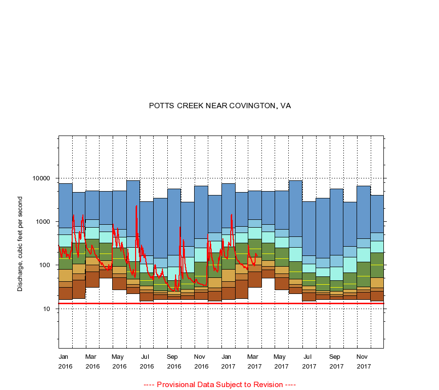
POTTS CREEK NEAR COVINGTON, VA
|
Minimum daily flow
|
|
|
5th percentile
|
|
|
|
10th percentile
|
|
|
|
|
25th percentile
|
|
|
|
|
|
Median
|
|
|
|
|
|
|
75th percentile
|
|
|
|
|
|
|
|
90th percentile
|
|
|
|
|
|
|
|
|
95th percentile
|
|
|
|
|
|
|
|
|
|
Maximum daily flow
|
|
|
|
|
|
|
|
|
|
|
|
Years of record
|
January
|
16.0
|
31.0
|
42.0
|
80.0
|
141
|
262
|
496
|
712
|
7,430
|
|
78
|
February
|
17.0
|
45.2
|
64.0
|
105
|
185
|
320
|
559
|
772
|
4,740
|
|
78
|
March
|
31.0
|
71.0
|
101
|
153
|
234
|
398
|
728
|
1,120
|
5,160
|
|
78
|
April
|
50.0
|
78.0
|
94.0
|
126
|
182
|
321
|
580
|
869
|
5,030
|
|
78
|
May
|
27.0
|
52.0
|
64.0
|
94.0
|
142
|
252
|
444
|
670
|
5,100
|
|
78
|
June
|
22.0
|
31.0
|
36.0
|
48.2
|
71.0
|
122
|
255
|
456
|
8,870
|
|
78
|
July
|
15.0
|
23.0
|
27.0
|
33.0
|
44.0
|
67.0
|
107
|
164
|
2,890
|
|
78
|
August
|
16.0
|
21.0
|
23.0
|
26.0
|
36.0
|
54.0
|
87.0
|
145
|
3,510
|
|
78
|
September
|
16.0
|
19.0
|
21.0
|
25.0
|
31.0
|
44.0
|
90.9
|
168
|
5,590
|
|
78
|
October
|
16.0
|
20.0
|
22.9
|
28.0
|
37.0
|
66.0
|
151
|
268
|
2,850
|
|
78
|
November
|
16.0
|
24.0
|
27.0
|
32.0
|
56.0
|
119
|
247
|
403
|
6,600
|
|
78
|
December
|
15.0
|
25.0
|
30.0
|
52.0
|
100
|
191
|
359
|
548
|
4,050
|
|
78
|
|
|
Instantaneous minimum flow for period of record =
13.0
cubic feet per second.
The current daily value for 03/22/2017 is 161.0 cubic feet per second.
----
Provisional Data Subject to Revision ----
|