|
02016000
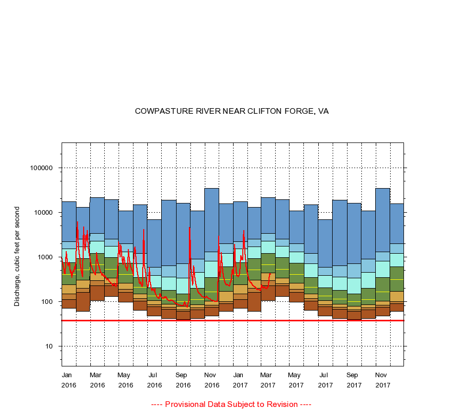
COWPASTURE RIVER NEAR CLIFTON FORGE, VA
|
Minimum daily flow
|
|
|
5th percentile
|
|
|
|
10th percentile
|
|
|
|
|
25th percentile
|
|
|
|
|
|
Median
|
|
|
|
|
|
|
75th percentile
|
|
|
|
|
|
|
|
90th percentile
|
|
|
|
|
|
|
|
|
95th percentile
|
|
|
|
|
|
|
|
|
|
Maximum daily flow
|
|
|
|
|
|
|
|
|
|
|
|
Years of record
|
January
|
70.0
|
110
|
150
|
240
|
400
|
750
|
1,500
|
2,200
|
17,400
|
|
90
|
February
|
60.0
|
160
|
200
|
299
|
520
|
915
|
1,670
|
2,490
|
12,800
|
|
90
|
March
|
105
|
229
|
293
|
434
|
664
|
1,190
|
2,250
|
3,360
|
21,400
|
|
90
|
April
|
130
|
226
|
253
|
334
|
532
|
960
|
1,720
|
2,520
|
19,400
|
|
90
|
May
|
98.0
|
160
|
188
|
261
|
409
|
716
|
1,280
|
1,980
|
10,800
|
|
90
|
June
|
63.0
|
103
|
116
|
147
|
207
|
343
|
709
|
1,190
|
14,800
|
|
90
|
July
|
47.0
|
76.0
|
86.0
|
105
|
134
|
205
|
384
|
593
|
6,760
|
|
90
|
August
|
42.0
|
67.0
|
74.0
|
87.0
|
114
|
178
|
351
|
638
|
18,800
|
|
90
|
September
|
40.0
|
61.0
|
66.0
|
78.0
|
99.0
|
150
|
341
|
710
|
16,000
|
|
90
|
October
|
42.0
|
65.0
|
73.0
|
86.0
|
110
|
197
|
452
|
892
|
10,700
|
|
90
|
November
|
48.0
|
75.0
|
84.0
|
102
|
165
|
346
|
799
|
1,300
|
33,900
|
|
90
|
December
|
60.0
|
89.0
|
100
|
171
|
313
|
606
|
1,210
|
1,960
|
15,400
|
|
90
|
|
|
Instantaneous minimum flow for period of record =
38.0
cubic feet per second.
The current daily value for 03/22/2017 is 403.0 cubic feet per second.
----
Provisional Data Subject to Revision ----
|