|
02020500
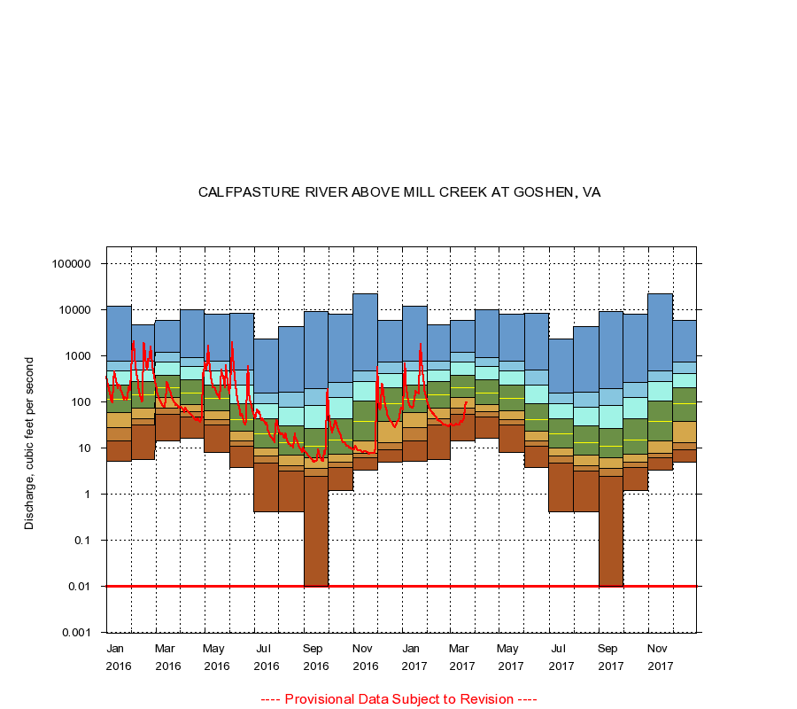
CALFPASTURE RIVER ABOVE MILL CREEK AT GOSHEN, VA
|
Minimum daily flow
|
|
|
5th percentile
|
|
|
|
10th percentile
|
|
|
|
|
25th percentile
|
|
|
|
|
|
Median
|
|
|
|
|
|
|
75th percentile
|
|
|
|
|
|
|
|
90th percentile
|
|
|
|
|
|
|
|
|
95th percentile
|
|
|
|
|
|
|
|
|
|
Maximum daily flow
|
|
|
|
|
|
|
|
|
|
|
|
Years of record
|
January
|
5.00
|
14.3
|
28.0
|
59.0
|
112
|
228
|
473
|
749
|
12,100
|
|
75
|
February
|
5.60
|
31.0
|
42.0
|
74.0
|
143
|
273
|
497
|
752
|
4,790
|
|
75
|
March
|
14.0
|
54.0
|
72.6
|
124
|
206
|
373
|
740
|
1,170
|
5,990
|
|
75
|
April
|
16.0
|
47.6
|
60.0
|
88.0
|
155
|
295
|
588
|
899
|
9,940
|
|
75
|
May
|
8.10
|
32.0
|
40.6
|
65.0
|
119
|
228
|
464
|
751
|
7,980
|
|
75
|
June
|
3.70
|
11.0
|
14.0
|
23.0
|
40.5
|
91.0
|
232
|
500
|
8,560
|
|
75
|
July
|
0.40
|
4.73
|
6.60
|
10.0
|
20.0
|
42.0
|
92.0
|
154
|
2,270
|
|
75
|
August
|
0.40
|
3.20
|
4.06
|
7.00
|
13.0
|
30.0
|
77.0
|
165
|
4,390
|
|
75
|
September
|
0.00
|
2.40
|
3.61
|
6.00
|
11.0
|
26.0
|
84.0
|
196
|
9,360
|
|
75
|
October
|
1.20
|
3.80
|
4.86
|
7.30
|
15.0
|
42.0
|
123
|
261
|
7,910
|
|
75
|
November
|
3.30
|
6.10
|
7.60
|
14.0
|
38.0
|
103
|
270
|
460
|
21,900
|
|
75
|
December
|
4.90
|
9.20
|
13.0
|
38.0
|
91.0
|
204
|
416
|
733
|
5,910
|
|
75
|
|
|
Instantaneous minimum flow for period of record =
0.00
cubic feet per second.
Flow values of 0.00 are plotted as 0.01
The current daily value for 03/22/2017 is 95.0 cubic feet per second.
----
Provisional Data Subject to Revision ----
|