|
02027000
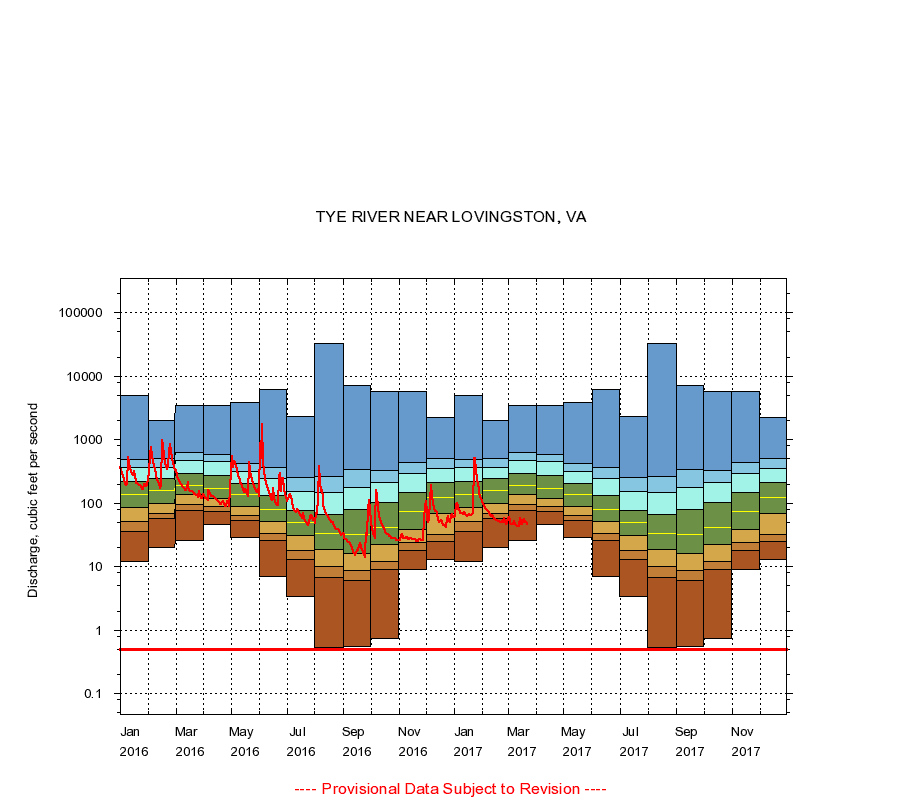
TYE RIVER NEAR LOVINGSTON, VA
|
Minimum daily flow
|
|
|
5th percentile
|
|
|
|
10th percentile
|
|
|
|
|
25th percentile
|
|
|
|
|
|
Median
|
|
|
|
|
|
|
75th percentile
|
|
|
|
|
|
|
|
90th percentile
|
|
|
|
|
|
|
|
|
95th percentile
|
|
|
|
|
|
|
|
|
|
Maximum daily flow
|
|
|
|
|
|
|
|
|
|
|
|
Years of record
|
January
|
12.0
|
36.0
|
51.0
|
85.0
|
135
|
220
|
367
|
497
|
5,050
|
|
77
|
February
|
20.0
|
58.0
|
69.0
|
100
|
156
|
241
|
359
|
512
|
2,030
|
|
77
|
March
|
26.0
|
77.0
|
95.8
|
135
|
192
|
298
|
472
|
631
|
3,500
|
|
77
|
April
|
47.0
|
75.0
|
89.0
|
118
|
172
|
273
|
448
|
595
|
3,500
|
|
77
|
May
|
29.0
|
53.0
|
64.0
|
89.0
|
136
|
204
|
318
|
423
|
3,830
|
|
77
|
June
|
7.10
|
26.0
|
33.1
|
52.0
|
80.0
|
134
|
241
|
362
|
6,200
|
|
77
|
July
|
3.40
|
13.0
|
18.0
|
31.0
|
49.0
|
78.0
|
155
|
251
|
2,300
|
|
77
|
August
|
0.53
|
6.80
|
10.0
|
19.0
|
33.0
|
66.0
|
149
|
259
|
32,600
|
|
77
|
September
|
0.55
|
5.96
|
8.60
|
16.0
|
32.0
|
80.0
|
176
|
337
|
7,180
|
|
77
|
October
|
0.73
|
9.00
|
12.0
|
22.0
|
42.0
|
102
|
216
|
324
|
5,760
|
|
77
|
November
|
9.00
|
18.0
|
24.0
|
38.0
|
75.0
|
148
|
293
|
443
|
5,760
|
|
77
|
December
|
13.0
|
25.0
|
32.0
|
69.0
|
123
|
213
|
356
|
514
|
2,240
|
|
77
|
|
|
Instantaneous minimum flow for period of record =
0.50
cubic feet per second.
The current daily value for 03/22/2017 is 47.0 cubic feet per second.
----
Provisional Data Subject to Revision ----
|