|
02030000
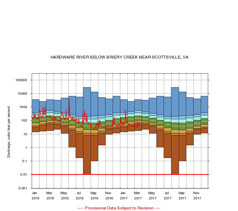
HARDWARE RIVER BELOW BRIERY CREEK NEAR SCOTTSVILLE, VA
|
Minimum daily flow
|
|
|
5th percentile
|
|
|
|
10th percentile
|
|
|
|
|
25th percentile
|
|
|
|
|
|
Median
|
|
|
|
|
|
|
75th percentile
|
|
|
|
|
|
|
|
90th percentile
|
|
|
|
|
|
|
|
|
95th percentile
|
|
|
|
|
|
|
|
|
|
Maximum daily flow
|
|
|
|
|
|
|
|
|
|
|
|
Years of record
|
January
|
14.0
|
33.0
|
41.0
|
65.0
|
105
|
163
|
271
|
393
|
3,610
|
|
76
|
February
|
16.0
|
46.0
|
56.0
|
80.0
|
126
|
192
|
306
|
440
|
2,600
|
|
76
|
March
|
18.0
|
57.0
|
73.0
|
102
|
143
|
221
|
370
|
560
|
3,580
|
|
76
|
April
|
22.0
|
54.0
|
67.0
|
88.0
|
128
|
195
|
306
|
428
|
3,290
|
|
76
|
May
|
11.0
|
39.0
|
47.0
|
66.0
|
98.0
|
152
|
233
|
337
|
4,570
|
|
76
|
June
|
1.10
|
20.0
|
28.0
|
43.0
|
72.0
|
108
|
176
|
257
|
6,420
|
|
76
|
July
|
0.17
|
11.0
|
16.0
|
29.0
|
51.0
|
78.0
|
134
|
198
|
5,560
|
|
76
|
August
|
0.00
|
7.70
|
12.0
|
21.0
|
40.0
|
69.0
|
130
|
195
|
28,400
|
|
76
|
September
|
0.10
|
7.90
|
11.0
|
20.0
|
36.0
|
64.0
|
129
|
216
|
13,000
|
|
76
|
October
|
1.50
|
12.0
|
17.0
|
26.0
|
44.0
|
80.0
|
154
|
239
|
5,070
|
|
76
|
November
|
9.50
|
23.0
|
27.0
|
38.0
|
60.0
|
106
|
186
|
274
|
4,050
|
|
76
|
December
|
12.0
|
28.0
|
33.7
|
51.0
|
90.0
|
140
|
253
|
379
|
6,300
|
|
76
|
|
|
Instantaneous minimum flow for period of record =
0.00
cubic feet per second.
Flow values of 0.00 are plotted as 0.01
The current daily value for 03/22/2017 is 40.0 cubic feet per second.
----
Provisional Data Subject to Revision ----
|