|
02031000
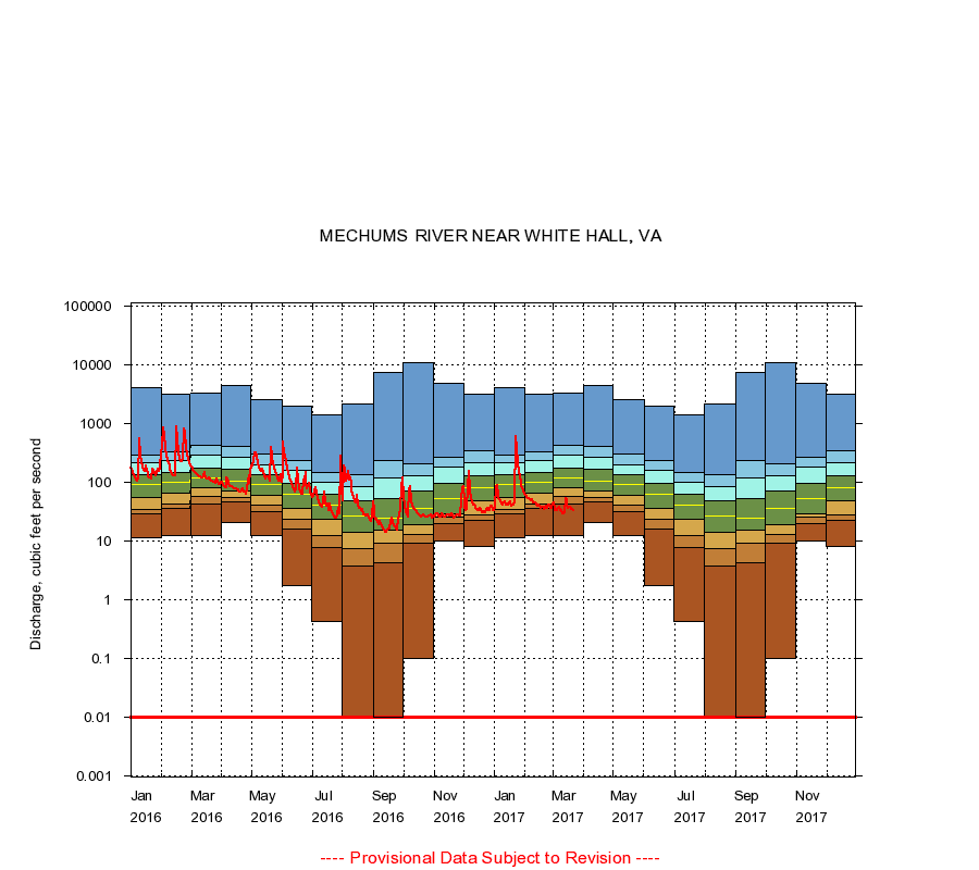
MECHUMS RIVER NEAR WHITE HALL, VA
|
Minimum daily flow
|
|
|
5th percentile
|
|
|
|
10th percentile
|
|
|
|
|
25th percentile
|
|
|
|
|
|
Median
|
|
|
|
|
|
|
75th percentile
|
|
|
|
|
|
|
|
90th percentile
|
|
|
|
|
|
|
|
|
95th percentile
|
|
|
|
|
|
|
|
|
|
Maximum daily flow
|
|
|
|
|
|
|
|
|
|
|
|
Years of record
|
January
|
11.0
|
29.0
|
34.0
|
55.0
|
90.0
|
132
|
213
|
286
|
4,000
|
|
45
|
February
|
12.0
|
35.0
|
42.0
|
65.0
|
99.0
|
145
|
234
|
323
|
3,090
|
|
45
|
March
|
12.0
|
41.8
|
57.0
|
81.0
|
116
|
174
|
286
|
414
|
3,220
|
|
45
|
April
|
20.0
|
45.6
|
54.0
|
70.0
|
102
|
164
|
269
|
402
|
4,390
|
|
45
|
May
|
12.0
|
31.0
|
40.0
|
58.0
|
89.0
|
132
|
197
|
298
|
2,580
|
|
45
|
June
|
1.70
|
15.6
|
23.0
|
36.0
|
61.0
|
94.0
|
159
|
235
|
1,930
|
|
45
|
July
|
0.42
|
7.80
|
12.0
|
23.0
|
40.0
|
63.0
|
99.0
|
147
|
1,420
|
|
45
|
August
|
0.00
|
3.70
|
7.36
|
14.0
|
26.0
|
48.0
|
85.0
|
135
|
2,170
|
|
45
|
September
|
0.00
|
4.15
|
8.91
|
15.0
|
24.0
|
52.0
|
118
|
230
|
7,400
|
|
45
|
October
|
0.10
|
9.20
|
13.0
|
19.0
|
35.0
|
70.0
|
127
|
207
|
10,600
|
|
45
|
November
|
10.0
|
19.6
|
25.0
|
29.0
|
51.5
|
94.0
|
177
|
259
|
4,800
|
|
45
|
December
|
8.00
|
22.0
|
27.6
|
48.0
|
80.0
|
126
|
212
|
340
|
3,150
|
|
45
|
|
|
Instantaneous minimum flow for period of record =
0.00
cubic feet per second.
Flow values of 0.00 are plotted as 0.01
The current daily value for 03/22/2017 is 33.0 cubic feet per second.
----
Provisional Data Subject to Revision ----
|