|
02032640
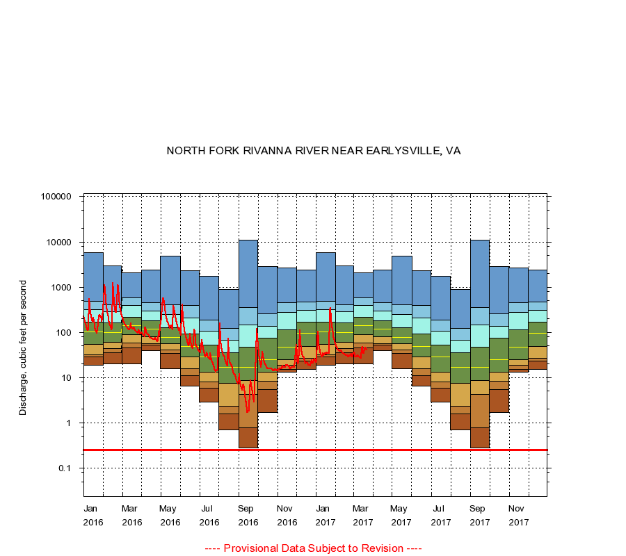
NORTH FORK RIVANNA RIVER NEAR EARLYSVILLE, VA
|
Minimum daily flow
|
|
|
5th percentile
|
|
|
|
10th percentile
|
|
|
|
|
25th percentile
|
|
|
|
|
|
Median
|
|
|
|
|
|
|
75th percentile
|
|
|
|
|
|
|
|
90th percentile
|
|
|
|
|
|
|
|
|
95th percentile
|
|
|
|
|
|
|
|
|
|
Maximum daily flow
|
|
|
|
|
|
|
|
|
|
|
|
Years of record
|
January
|
19.0
|
29.0
|
32.0
|
55.0
|
102
|
167
|
319
|
488
|
5,720
|
|
22
|
February
|
20.0
|
35.1
|
44.2
|
59.5
|
99.0
|
161
|
282
|
403
|
2,940
|
|
22
|
March
|
20.0
|
46.2
|
58.0
|
89.0
|
140
|
217
|
399
|
580
|
2,090
|
|
22
|
April
|
40.0
|
53.0
|
57.1
|
81.0
|
117
|
178
|
300
|
454
|
2,420
|
|
22
|
May
|
16.0
|
34.0
|
41.0
|
56.0
|
78.5
|
128
|
247
|
413
|
4,800
|
|
22
|
June
|
6.50
|
11.0
|
16.0
|
29.0
|
49.0
|
93.0
|
211
|
388
|
2,270
|
|
22
|
July
|
2.90
|
5.90
|
8.03
|
13.0
|
29.0
|
53.2
|
108
|
185
|
1,720
|
|
22
|
August
|
0.69
|
1.60
|
2.30
|
7.40
|
17.0
|
36.0
|
67.7
|
123
|
899
|
|
22
|
September
|
0.28
|
0.78
|
4.21
|
8.50
|
17.0
|
46.8
|
146
|
360
|
11,000
|
|
22
|
October
|
1.70
|
5.50
|
8.23
|
13.0
|
25.0
|
74.0
|
134
|
254
|
2,890
|
|
22
|
November
|
13.0
|
15.0
|
19.0
|
25.0
|
48.0
|
115
|
276
|
459
|
2,650
|
|
22
|
December
|
15.0
|
23.0
|
27.0
|
49.0
|
97.0
|
171
|
304
|
472
|
2,420
|
|
22
|
|
|
Instantaneous minimum flow for period of record =
0.25
cubic feet per second.
The current daily value for 03/22/2017 is 41.0 cubic feet per second.
----
Provisional Data Subject to Revision ----
|