|
02034000
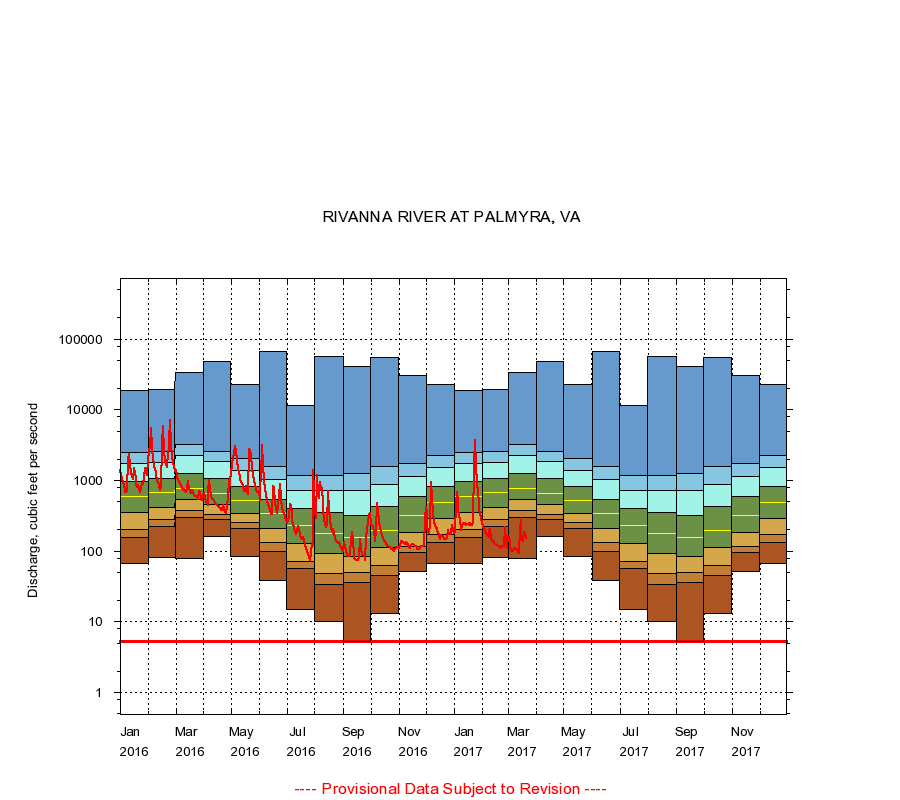
RIVANNA RIVER AT PALMYRA, VA
|
Minimum daily flow
|
|
|
5th percentile
|
|
|
|
10th percentile
|
|
|
|
|
25th percentile
|
|
|
|
|
|
Median
|
|
|
|
|
|
|
75th percentile
|
|
|
|
|
|
|
|
90th percentile
|
|
|
|
|
|
|
|
|
95th percentile
|
|
|
|
|
|
|
|
|
|
Maximum daily flow
|
|
|
|
|
|
|
|
|
|
|
|
Years of record
|
January
|
68.0
|
156
|
205
|
353
|
593
|
974
|
1,730
|
2,520
|
19,000
|
|
81
|
February
|
82.0
|
226
|
281
|
421
|
667
|
1,070
|
1,780
|
2,600
|
19,500
|
|
81
|
March
|
80.0
|
301
|
372
|
531
|
780
|
1,240
|
2,240
|
3,210
|
33,800
|
|
81
|
April
|
162
|
280
|
335
|
458
|
660
|
1,080
|
1,860
|
2,600
|
49,000
|
|
81
|
May
|
84.0
|
210
|
251
|
344
|
525
|
822
|
1,370
|
2,080
|
22,900
|
|
81
|
June
|
38.0
|
99.0
|
133
|
209
|
337
|
546
|
1,020
|
1,590
|
68,000
|
|
81
|
July
|
15.0
|
56.6
|
72.0
|
127
|
233
|
399
|
720
|
1,190
|
11,600
|
|
81
|
August
|
10.0
|
34.0
|
49.0
|
92.0
|
179
|
352
|
716
|
1,170
|
57,000
|
|
81
|
September
|
5.20
|
36.0
|
50.0
|
85.0
|
158
|
319
|
713
|
1,240
|
40,800
|
|
81
|
October
|
13.0
|
46.0
|
63.0
|
112
|
199
|
428
|
882
|
1,600
|
55,500
|
|
81
|
November
|
52.0
|
95.0
|
117
|
185
|
316
|
587
|
1,150
|
1,770
|
31,000
|
|
81
|
December
|
67.0
|
135
|
170
|
290
|
491
|
827
|
1,520
|
2,240
|
23,200
|
|
81
|
|
|
Instantaneous minimum flow for period of record =
5.20
cubic feet per second.
The current daily value for 03/22/2017 is not determined.
----
Provisional Data Subject to Revision ----
|