|
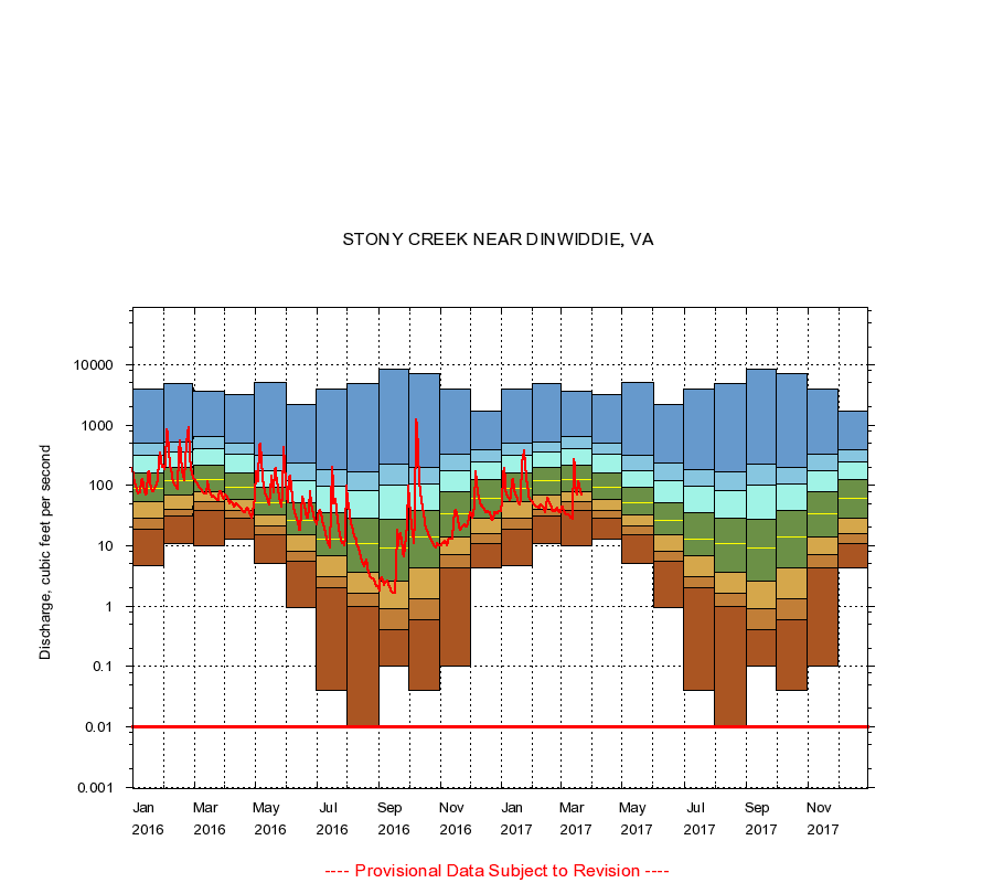
02046000
STONY CREEK NEAR DINWIDDIE, VA
|
Minimum daily flow
|
|
|
5th percentile
|
|
|
|
10th percentile
|
|
|
|
|
25th percentile
|
|
|
|
|
|
Median
|
|
|
|
|
|
|
75th percentile
|
|
|
|
|
|
|
|
90th percentile
|
|
|
|
|
|
|
|
|
95th percentile
|
|
|
|
|
|
|
|
|
|
Maximum daily flow
|
|
|
|
|
|
|
|
|
|
|
|
Years of record
|
January
|
4.70
|
19.0
|
29.0
|
53.0
|
89.0
|
161
|
321
|
496
|
3,890
|
|
69
|
February
|
11.0
|
31.0
|
40.0
|
69.0
|
122
|
200
|
355
|
514
|
4,780
|
|
69
|
March
|
10.0
|
39.0
|
53.0
|
80.0
|
124
|
216
|
399
|
644
|
3,700
|
|
69
|
April
|
13.0
|
29.0
|
39.1
|
59.0
|
94.0
|
163
|
323
|
511
|
3,270
|
|
69
|
May
|
5.00
|
15.0
|
21.0
|
32.0
|
52.0
|
93.0
|
172
|
315
|
5,050
|
|
69
|
June
|
0.94
|
5.56
|
8.21
|
15.0
|
26.0
|
51.2
|
120
|
234
|
2,230
|
|
69
|
July
|
0.04
|
2.00
|
3.10
|
6.80
|
13.0
|
35.0
|
97.0
|
180
|
3,980
|
|
69
|
August
|
0.00
|
1.00
|
1.60
|
3.60
|
11.0
|
29.0
|
82.0
|
168
|
4,830
|
|
69
|
September
|
0.10
|
0.40
|
0.90
|
2.60
|
9.20
|
27.0
|
100
|
228
|
8,400
|
|
69
|
October
|
0.04
|
0.60
|
1.30
|
4.30
|
14.0
|
39.0
|
106
|
196
|
7,050
|
|
69
|
November
|
0.10
|
4.30
|
7.00
|
14.0
|
34.0
|
77.2
|
178
|
329
|
3,960
|
|
69
|
December
|
4.30
|
11.0
|
16.0
|
29.0
|
60.0
|
124
|
248
|
384
|
1,680
|
|
69
|
|
|
Instantaneous minimum flow for period of record =
0.00
cubic feet per second.
Flow values of 0.00 are plotted as 0.01
The current daily value for 03/22/2017 is 68.0 cubic feet per second.
----
Provisional Data Subject to Revision ----
|