|
02054500
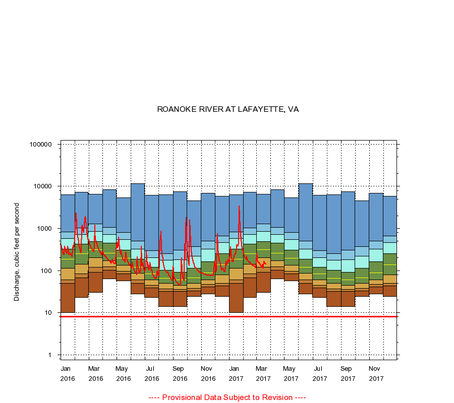
ROANOKE RIVER AT LAFAYETTE, VA
|
Minimum daily flow
|
|
|
5th percentile
|
|
|
|
10th percentile
|
|
|
|
|
25th percentile
|
|
|
|
|
|
Median
|
|
|
|
|
|
|
75th percentile
|
|
|
|
|
|
|
|
90th percentile
|
|
|
|
|
|
|
|
|
95th percentile
|
|
|
|
|
|
|
|
|
|
Maximum daily flow
|
|
|
|
|
|
|
|
|
|
|
|
Years of record
|
January
|
10.0
|
49.0
|
60.0
|
112
|
186
|
324
|
570
|
819
|
6,360
|
|
72
|
February
|
23.0
|
67.0
|
84.0
|
142
|
250
|
427
|
723
|
1,020
|
7,190
|
|
72
|
March
|
30.0
|
90.0
|
119
|
201
|
313
|
491
|
840
|
1,280
|
6,570
|
|
72
|
April
|
63.0
|
103
|
122
|
173
|
261
|
445
|
710
|
1,060
|
8,260
|
|
72
|
May
|
57.0
|
83.0
|
96.0
|
134
|
198
|
305
|
542
|
805
|
5,340
|
|
72
|
June
|
28.0
|
49.0
|
60.0
|
87.0
|
120
|
185
|
323
|
506
|
11,700
|
|
72
|
July
|
23.0
|
39.0
|
45.0
|
60.0
|
83.0
|
121
|
200
|
295
|
6,170
|
|
72
|
August
|
14.0
|
32.0
|
36.3
|
49.0
|
66.0
|
102
|
174
|
252
|
6,350
|
|
72
|
September
|
14.0
|
32.0
|
36.0
|
45.0
|
59.5
|
91.0
|
182
|
308
|
7,420
|
|
72
|
October
|
24.0
|
33.0
|
38.0
|
50.0
|
68.0
|
114
|
220
|
375
|
4,600
|
|
72
|
November
|
28.0
|
41.0
|
47.0
|
60.0
|
89.0
|
162
|
321
|
498
|
6,840
|
|
72
|
December
|
24.0
|
43.0
|
50.0
|
78.2
|
138
|
249
|
460
|
655
|
5,760
|
|
72
|
|
|
Instantaneous minimum flow for period of record =
8.00
cubic feet per second.
The current daily value for 03/22/2017 is 141.0 cubic feet per second.
----
Provisional Data Subject to Revision ----
|