|
02054530
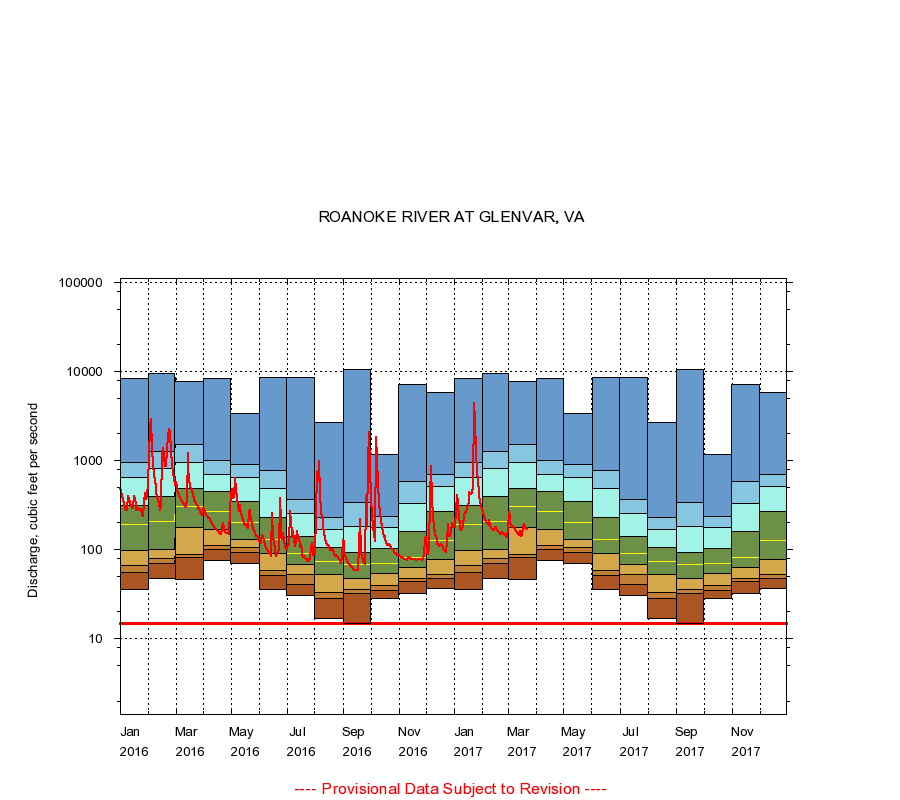
ROANOKE RIVER AT GLENVAR, VA
|
Minimum daily flow
|
|
|
5th percentile
|
|
|
|
10th percentile
|
|
|
|
|
25th percentile
|
|
|
|
|
|
Median
|
|
|
|
|
|
|
75th percentile
|
|
|
|
|
|
|
|
90th percentile
|
|
|
|
|
|
|
|
|
95th percentile
|
|
|
|
|
|
|
|
|
|
Maximum daily flow
|
|
|
|
|
|
|
|
|
|
|
|
Years of record
|
January
|
36.0
|
55.2
|
67.0
|
97.0
|
191
|
316
|
651
|
964
|
8,490
|
|
24
|
February
|
48.0
|
70.0
|
80.0
|
102
|
209
|
392
|
824
|
1,270
|
9,620
|
|
24
|
March
|
46.0
|
82.0
|
88.0
|
178
|
310
|
486
|
948
|
1,540
|
7,800
|
|
24
|
April
|
76.0
|
102
|
112
|
169
|
268
|
456
|
702
|
1,010
|
8,380
|
|
24
|
May
|
70.0
|
94.2
|
107
|
131
|
202
|
353
|
651
|
903
|
3,420
|
|
24
|
June
|
36.0
|
51.0
|
59.0
|
90.0
|
132
|
233
|
482
|
776
|
8,580
|
|
24
|
July
|
31.0
|
41.0
|
53.0
|
69.0
|
92.0
|
140
|
257
|
367
|
8,730
|
|
24
|
August
|
17.0
|
28.0
|
33.5
|
53.2
|
74.0
|
105
|
170
|
230
|
2,720
|
|
24
|
September
|
15.0
|
32.0
|
36.0
|
47.0
|
68.5
|
93.0
|
182
|
344
|
10,500
|
|
24
|
October
|
28.0
|
35.0
|
40.0
|
54.0
|
71.0
|
103
|
178
|
238
|
1,180
|
|
23
|
November
|
32.0
|
43.6
|
47.0
|
63.0
|
82.5
|
160
|
334
|
587
|
7,110
|
|
23
|
December
|
37.0
|
48.0
|
53.0
|
77.0
|
127
|
270
|
519
|
693
|
5,850
|
|
23
|
|
|
Instantaneous minimum flow for period of record =
15.0
cubic feet per second.
The current daily value for 03/22/2017 is 170.0 cubic feet per second.
----
Provisional Data Subject to Revision ----
|