|
02055000
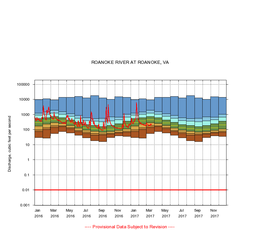
ROANOKE RIVER AT ROANOKE, VA
|
Minimum daily flow
|
|
|
5th percentile
|
|
|
|
10th percentile
|
|
|
|
|
25th percentile
|
|
|
|
|
|
Median
|
|
|
|
|
|
|
75th percentile
|
|
|
|
|
|
|
|
90th percentile
|
|
|
|
|
|
|
|
|
95th percentile
|
|
|
|
|
|
|
|
|
|
Maximum daily flow
|
|
|
|
|
|
|
|
|
|
|
|
Years of record
|
January
|
30.0
|
75.0
|
96.1
|
174
|
294
|
537
|
895
|
1,260
|
9,820
|
|
115
|
February
|
27.0
|
102
|
130
|
230
|
376
|
620
|
1,050
|
1,510
|
11,100
|
|
117
|
March
|
54.0
|
141
|
182
|
290
|
460
|
734
|
1,260
|
1,910
|
9,200
|
|
117
|
April
|
74.0
|
157
|
183
|
256
|
376
|
623
|
1,040
|
1,540
|
13,800
|
|
117
|
May
|
60.0
|
116
|
140
|
191
|
280
|
431
|
754
|
1,150
|
13,600
|
|
117
|
June
|
43.0
|
76.0
|
90.1
|
126
|
184
|
301
|
566
|
855
|
15,900
|
|
117
|
July
|
29.0
|
55.0
|
67.0
|
93.0
|
135
|
218
|
400
|
611
|
12,700
|
|
117
|
August
|
18.0
|
43.0
|
55.0
|
77.0
|
114
|
184
|
360
|
536
|
18,200
|
|
117
|
September
|
16.0
|
45.0
|
52.0
|
69.0
|
98.0
|
156
|
328
|
573
|
12,900
|
|
117
|
October
|
30.0
|
50.0
|
56.6
|
76.0
|
108
|
184
|
377
|
688
|
10,200
|
|
115
|
November
|
38.0
|
60.0
|
68.0
|
89.0
|
132
|
240
|
460
|
674
|
15,000
|
|
115
|
December
|
35.0
|
65.0
|
78.0
|
112
|
205
|
360
|
680
|
1,040
|
13,600
|
|
115
|
|
|
Instantaneous minimum flow for period of record =
0.00
cubic feet per second.
Flow values of 0.00 are plotted as 0.01
The current daily value for 03/22/2017 is 209.0 cubic feet per second.
----
Provisional Data Subject to Revision ----
|