|
02059500
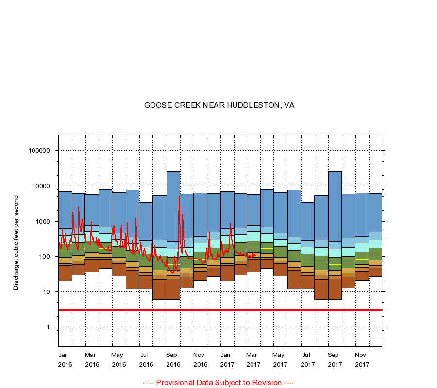
GOOSE CREEK NEAR HUDDLESTON, VA
|
Minimum daily flow
|
|
|
5th percentile
|
|
|
|
10th percentile
|
|
|
|
|
25th percentile
|
|
|
|
|
|
Median
|
|
|
|
|
|
|
75th percentile
|
|
|
|
|
|
|
|
90th percentile
|
|
|
|
|
|
|
|
|
95th percentile
|
|
|
|
|
|
|
|
|
|
Maximum daily flow
|
|
|
|
|
|
|
|
|
|
|
|
Years of record
|
January
|
20.0
|
54.8
|
64.0
|
94.0
|
142
|
222
|
400
|
610
|
7,100
|
|
85
|
February
|
30.0
|
60.0
|
75.0
|
108
|
164
|
250
|
418
|
626
|
6,220
|
|
85
|
March
|
37.0
|
81.0
|
96.0
|
132
|
184
|
278
|
509
|
771
|
5,560
|
|
85
|
April
|
46.0
|
82.0
|
94.0
|
123
|
167
|
246
|
453
|
676
|
8,080
|
|
85
|
May
|
28.0
|
64.0
|
73.0
|
96.0
|
133
|
192
|
303
|
469
|
6,600
|
|
85
|
June
|
12.0
|
40.0
|
49.0
|
71.0
|
104
|
146
|
231
|
362
|
7,630
|
|
85
|
July
|
12.0
|
29.0
|
36.0
|
52.0
|
78.0
|
118
|
188
|
284
|
3,360
|
|
85
|
August
|
6.00
|
22.0
|
30.0
|
42.0
|
66.0
|
105
|
177
|
300
|
5,370
|
|
85
|
September
|
6.00
|
23.0
|
29.0
|
40.0
|
60.0
|
94.0
|
162
|
274
|
26,000
|
|
85
|
October
|
13.0
|
26.0
|
35.0
|
48.0
|
65.0
|
102
|
178
|
337
|
5,860
|
|
85
|
November
|
21.0
|
38.6
|
49.0
|
60.0
|
82.0
|
133
|
241
|
371
|
6,470
|
|
85
|
December
|
27.0
|
47.0
|
56.0
|
80.0
|
117
|
173
|
298
|
495
|
6,160
|
|
85
|
|
|
Instantaneous minimum flow for period of record =
3.00
cubic feet per second.
The current daily value for 03/22/2017 is 108.0 cubic feet per second.
----
Provisional Data Subject to Revision ----
|