|
02069700
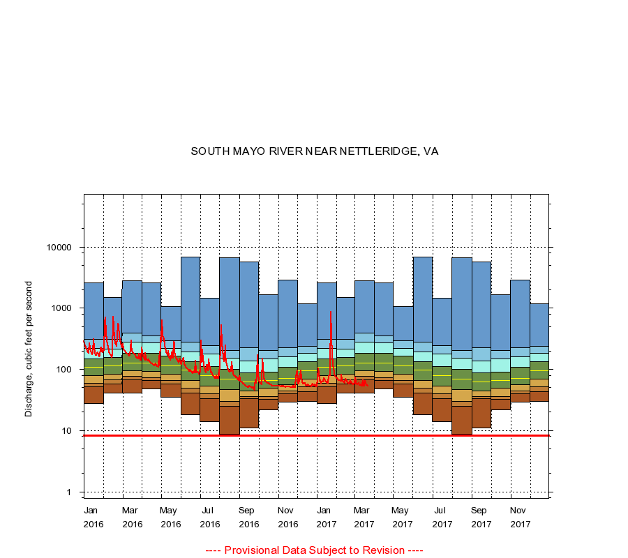
SOUTH MAYO RIVER NEAR NETTLERIDGE, VA
|
Minimum daily flow
|
|
|
5th percentile
|
|
|
|
10th percentile
|
|
|
|
|
25th percentile
|
|
|
|
|
|
Median
|
|
|
|
|
|
|
75th percentile
|
|
|
|
|
|
|
|
90th percentile
|
|
|
|
|
|
|
|
|
95th percentile
|
|
|
|
|
|
|
|
|
|
Maximum daily flow
|
|
|
|
|
|
|
|
|
|
|
|
Years of record
|
January
|
28.0
|
52.0
|
59.0
|
79.0
|
108
|
148
|
219
|
310
|
2,620
|
|
53
|
February
|
41.0
|
58.0
|
66.8
|
84.0
|
115
|
155
|
216
|
309
|
1,500
|
|
53
|
March
|
41.0
|
67.0
|
76.0
|
94.0
|
128
|
182
|
276
|
390
|
2,800
|
|
53
|
April
|
48.0
|
65.0
|
73.0
|
93.0
|
126
|
181
|
270
|
351
|
2,600
|
|
53
|
May
|
35.0
|
57.0
|
65.4
|
84.0
|
115
|
164
|
222
|
293
|
1,070
|
|
53
|
June
|
18.0
|
40.6
|
49.0
|
65.0
|
97.5
|
133
|
191
|
279
|
6,820
|
|
53
|
July
|
14.0
|
33.0
|
40.0
|
54.0
|
80.0
|
111
|
176
|
244
|
1,460
|
|
53
|
August
|
8.70
|
25.0
|
30.0
|
47.0
|
69.0
|
99.0
|
152
|
204
|
6,580
|
|
53
|
September
|
11.0
|
33.0
|
36.0
|
44.0
|
62.0
|
87.0
|
138
|
228
|
5,750
|
|
53
|
October
|
22.0
|
32.0
|
36.0
|
49.0
|
65.0
|
90.0
|
147
|
203
|
1,680
|
|
53
|
November
|
29.0
|
40.0
|
44.0
|
56.0
|
71.0
|
108
|
162
|
226
|
2,910
|
|
53
|
December
|
30.0
|
43.0
|
51.4
|
69.0
|
94.0
|
132
|
185
|
241
|
1,180
|
|
53
|
|
|
Instantaneous minimum flow for period of record =
8.30
cubic feet per second.
The current daily value for 03/22/2017 is 54.0 cubic feet per second.
----
Provisional Data Subject to Revision ----
|