|
02070000
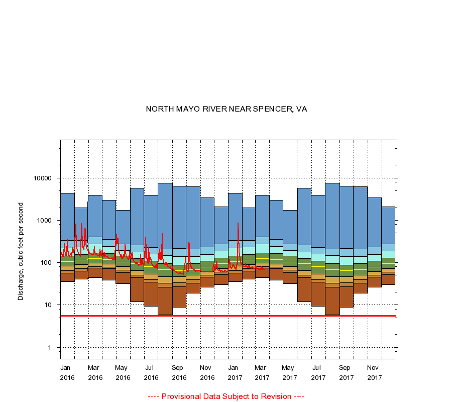
NORTH MAYO RIVER NEAR SPENCER, VA
|
Minimum daily flow
|
|
|
5th percentile
|
|
|
|
10th percentile
|
|
|
|
|
25th percentile
|
|
|
|
|
|
Median
|
|
|
|
|
|
|
75th percentile
|
|
|
|
|
|
|
|
90th percentile
|
|
|
|
|
|
|
|
|
95th percentile
|
|
|
|
|
|
|
|
|
|
Maximum daily flow
|
|
|
|
|
|
|
|
|
|
|
|
Years of record
|
January
|
36.0
|
57.0
|
65.7
|
82.0
|
106
|
143
|
224
|
330
|
4,350
|
|
86
|
February
|
41.0
|
63.0
|
72.0
|
89.0
|
115
|
155
|
233
|
335
|
1,980
|
|
86
|
March
|
44.0
|
74.0
|
81.0
|
98.0
|
124
|
169
|
275
|
406
|
3,900
|
|
86
|
April
|
39.0
|
72.0
|
78.0
|
93.0
|
118
|
165
|
244
|
355
|
2,980
|
|
86
|
May
|
32.0
|
58.0
|
66.0
|
80.0
|
104
|
145
|
195
|
275
|
1,740
|
|
86
|
June
|
12.0
|
44.0
|
51.0
|
65.0
|
94.0
|
124
|
179
|
259
|
5,790
|
|
86
|
July
|
9.20
|
35.0
|
40.0
|
54.0
|
81.0
|
109
|
161
|
229
|
3,870
|
|
86
|
August
|
5.90
|
26.0
|
33.0
|
47.0
|
69.0
|
96.0
|
147
|
208
|
7,460
|
|
86
|
September
|
8.90
|
27.0
|
34.0
|
47.0
|
65.0
|
87.0
|
139
|
214
|
6,490
|
|
86
|
October
|
19.0
|
33.0
|
40.0
|
51.0
|
69.0
|
96.0
|
139
|
210
|
6,160
|
|
86
|
November
|
26.0
|
45.0
|
50.0
|
61.0
|
78.0
|
109
|
154
|
233
|
3,380
|
|
86
|
December
|
30.0
|
51.4
|
59.0
|
72.0
|
95.0
|
128
|
186
|
278
|
2,100
|
|
86
|
|
|
Instantaneous minimum flow for period of record =
5.60
cubic feet per second.
The current daily value for 03/22/2017 is 68.0 cubic feet per second.
----
Provisional Data Subject to Revision ----
|