|
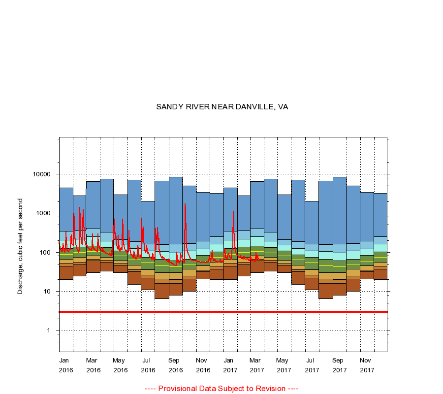
02074500
SANDY RIVER NEAR DANVILLE, VA
|
Minimum daily flow
|
|
|
5th percentile
|
|
|
|
10th percentile
|
|
|
|
|
25th percentile
|
|
|
|
|
|
Median
|
|
|
|
|
|
|
75th percentile
|
|
|
|
|
|
|
|
90th percentile
|
|
|
|
|
|
|
|
|
95th percentile
|
|
|
|
|
|
|
|
|
|
Maximum daily flow
|
|
|
|
|
|
|
|
|
|
|
|
Years of record
|
January
|
20.0
|
44.0
|
52.7
|
66.0
|
88.0
|
124
|
208
|
343
|
4,440
|
|
86
|
February
|
25.0
|
48.0
|
56.0
|
75.0
|
98.0
|
138
|
217
|
353
|
2,810
|
|
86
|
March
|
30.0
|
61.0
|
67.0
|
80.0
|
104
|
145
|
253
|
418
|
6,450
|
|
86
|
April
|
33.0
|
56.0
|
62.0
|
75.0
|
96.0
|
132
|
195
|
328
|
7,490
|
|
86
|
May
|
30.0
|
46.0
|
51.0
|
61.0
|
80.0
|
107
|
153
|
214
|
2,950
|
|
86
|
June
|
15.0
|
32.0
|
36.1
|
47.0
|
64.0
|
86.0
|
126
|
190
|
7,070
|
|
86
|
July
|
11.0
|
22.0
|
26.0
|
36.0
|
54.0
|
74.0
|
110
|
163
|
2,060
|
|
86
|
August
|
6.40
|
16.0
|
21.0
|
30.0
|
45.0
|
66.0
|
106
|
160
|
6,780
|
|
86
|
September
|
8.00
|
16.0
|
20.0
|
30.0
|
43.0
|
60.0
|
96.0
|
164
|
8,340
|
|
86
|
October
|
10.0
|
21.0
|
25.0
|
37.0
|
49.0
|
67.0
|
107
|
167
|
5,080
|
|
86
|
November
|
21.0
|
32.0
|
35.0
|
45.0
|
58.0
|
83.0
|
123
|
193
|
3,480
|
|
86
|
December
|
20.0
|
37.4
|
44.0
|
56.0
|
75.0
|
103
|
163
|
252
|
3,200
|
|
86
|
|
|
Instantaneous minimum flow for period of record =
3.00
cubic feet per second.
The current daily value for 03/22/2017 is 64.0 cubic feet per second.
----
Provisional Data Subject to Revision ----
|