|
03471500
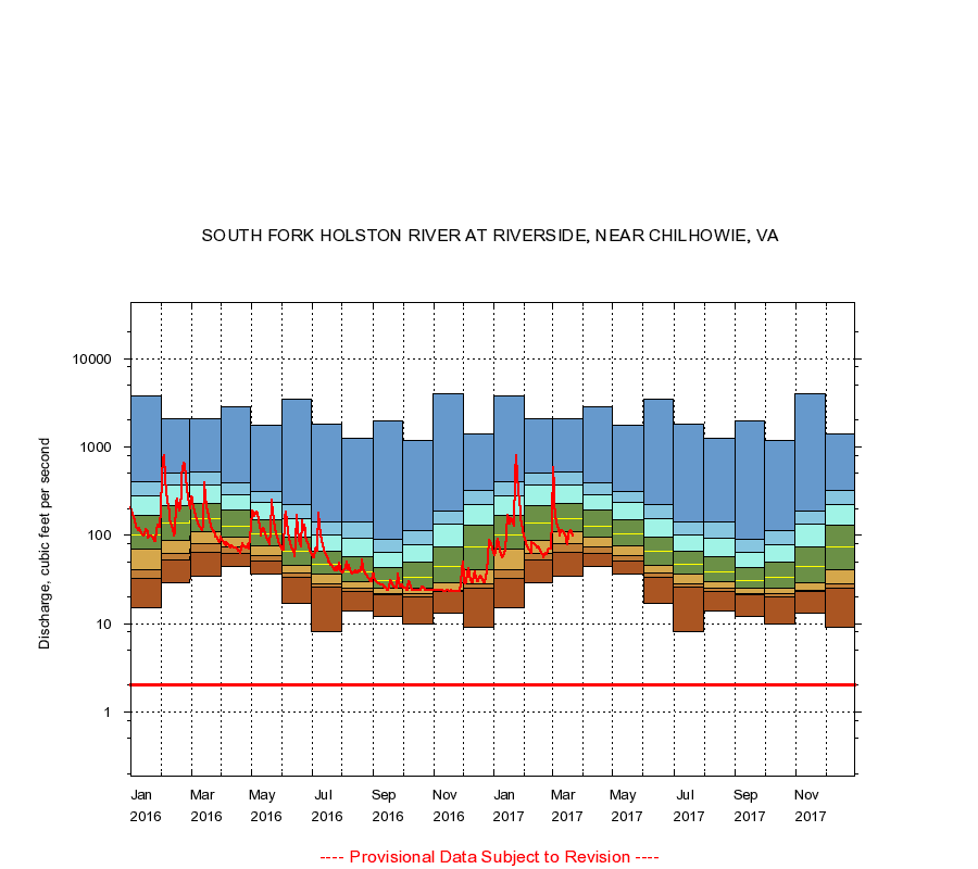
SOUTH FORK HOLSTON RIVER AT RIVERSIDE, NEAR CHILHOWIE, VA
|
Minimum daily flow
|
|
|
5th percentile
|
|
|
|
10th percentile
|
|
|
|
|
25th percentile
|
|
|
|
|
|
Median
|
|
|
|
|
|
|
75th percentile
|
|
|
|
|
|
|
|
90th percentile
|
|
|
|
|
|
|
|
|
95th percentile
|
|
|
|
|
|
|
|
|
|
Maximum daily flow
|
|
|
|
|
|
|
|
|
|
|
|
Years of record
|
January
|
15.0
|
32.2
|
41.0
|
70.0
|
102
|
166
|
280
|
398
|
3,780
|
|
84
|
February
|
29.0
|
53.0
|
63.0
|
88.0
|
137
|
218
|
366
|
503
|
2,080
|
|
84
|
March
|
34.0
|
64.0
|
81.0
|
109
|
155
|
230
|
366
|
514
|
2,070
|
|
84
|
April
|
44.0
|
62.0
|
74.0
|
94.0
|
126
|
192
|
287
|
394
|
2,870
|
|
84
|
May
|
36.0
|
51.0
|
58.0
|
75.2
|
104
|
151
|
235
|
316
|
1,770
|
|
84
|
June
|
17.0
|
33.0
|
37.0
|
46.0
|
65.0
|
96.0
|
155
|
222
|
3,450
|
|
84
|
July
|
8.00
|
26.0
|
28.0
|
36.0
|
47.0
|
66.0
|
102
|
143
|
1,820
|
|
84
|
August
|
14.0
|
23.0
|
25.0
|
30.0
|
39.0
|
57.0
|
92.0
|
140
|
1,250
|
|
85
|
September
|
12.0
|
21.0
|
22.0
|
25.0
|
31.0
|
43.0
|
64.0
|
90.4
|
1,940
|
|
85
|
October
|
10.0
|
20.0
|
22.0
|
25.0
|
33.0
|
49.0
|
78.4
|
114
|
1,170
|
|
85
|
November
|
13.0
|
23.0
|
24.0
|
29.0
|
44.0
|
73.0
|
132
|
188
|
4,040
|
|
85
|
December
|
9.00
|
25.0
|
28.0
|
41.0
|
73.0
|
129
|
220
|
325
|
1,380
|
|
85
|
|
|
Instantaneous minimum flow for period of record =
2.00
cubic feet per second.
The current daily value for 03/22/2017 is 99.0 cubic feet per second.
----
Provisional Data Subject to Revision ----
|