|
03529500
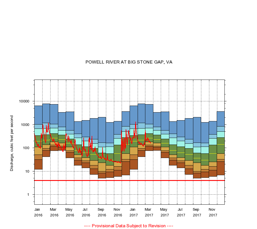
POWELL RIVER AT BIG STONE GAP, VA
|
Minimum daily flow
|
|
|
5th percentile
|
|
|
|
10th percentile
|
|
|
|
|
25th percentile
|
|
|
|
|
|
Median
|
|
|
|
|
|
|
75th percentile
|
|
|
|
|
|
|
|
90th percentile
|
|
|
|
|
|
|
|
|
95th percentile
|
|
|
|
|
|
|
|
|
|
Maximum daily flow
|
|
|
|
|
|
|
|
|
|
|
|
Years of record
|
January
|
12.0
|
32.0
|
51.3
|
110
|
192
|
335
|
678
|
1,020
|
6,330
|
|
32
|
February
|
42.0
|
79.0
|
94.0
|
136
|
214
|
366
|
681
|
1,160
|
7,860
|
|
32
|
March
|
77.0
|
117
|
133
|
184
|
263
|
412
|
708
|
1,050
|
7,280
|
|
32
|
April
|
79.0
|
106
|
119
|
161
|
230
|
357
|
560
|
792
|
3,360
|
|
32
|
May
|
37.0
|
64.0
|
77.0
|
110
|
157
|
242
|
396
|
562
|
3,580
|
|
32
|
June
|
18.0
|
30.0
|
37.0
|
51.0
|
79.0
|
138
|
270
|
404
|
1,360
|
|
32
|
July
|
14.0
|
23.0
|
28.0
|
38.2
|
62.0
|
112
|
197
|
297
|
1,520
|
|
32
|
August
|
7.20
|
13.0
|
18.0
|
29.0
|
52.0
|
95.8
|
153
|
238
|
1,860
|
|
32
|
September
|
5.00
|
8.40
|
10.0
|
23.0
|
36.0
|
60.0
|
111
|
169
|
2,070
|
|
32
|
October
|
5.30
|
9.46
|
12.0
|
18.0
|
30.0
|
58.0
|
113
|
164
|
1,250
|
|
32
|
November
|
6.00
|
11.0
|
16.0
|
25.0
|
58.0
|
135
|
253
|
377
|
1,390
|
|
32
|
December
|
6.80
|
26.0
|
33.0
|
57.0
|
140
|
280
|
504
|
846
|
3,620
|
|
32
|
|
|
Instantaneous minimum flow for period of record =
4.00
cubic feet per second.
The current daily value for 03/22/2017 is 160.0 cubic feet per second.
----
Provisional Data Subject to Revision ----
|