USGS home page

U.S. Geological Survey – Water Resources of Virginia

Photos Of Flooding: February 2003

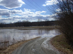
James River at Cartersville: Peak flow on 2/24/03 of 104,000 cubic feet per second (cfs); 5-year flood

Flooding, James River Feb 2003

Flooding, James River Feb 2003
Flooding, James River Feb 2003 Flooding, James River Feb 2003

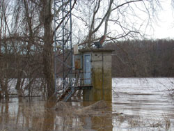
James River near Richmond: Peak flow on 2/25/03 of 113,000 cfs; 5-year flood
Flooding, James River, Richmond Feb 2003 Flooding, James River, Richmond Feb 2003
Flooding, James River, Richmond Feb 2003
Flooding, James River, Richmond Feb 2003 Flooding, James River, Richmond Feb 2003
Flooding, James River, Richmond Feb 2003
Flooding, James River, Richmond Feb 2003 Flooding, James River, Richmond Feb 2003
Flooding, James River, Richmond Feb 2003
Flooding, James River, Richmond Feb 2003 Flooding, James River, Richmond Feb 2003
Flooding, James River, Richmond Feb 2003


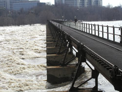
Rappahannock River near Fredericksburg: Peak flow on 2/23/03 of 26,400 cfs: 2-year flood
Flooding, Rappahannock River Feb 2003 Flooding, Rappahannock River Feb 2003
Flooding, Rappahannock River Feb 2003
Flooding, Rappahannock River Feb 2003 Flooding, Rappahannock River Feb 2003


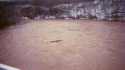
Pamunkey River near Hanover:
Peak flow on 2/25/03 of 15,100 cfs: 5-year flood
Flooding, Pamunkey River Feb 2003 Flooding, Pamunkey River Feb 2003


Mattaponi River near Beulahville:
Peak flow on 2/27/03 of 4,750 cfs: 5-year flood
Flooding, Mattaponi River Feb 2003 Flooding, Mattaponi River Feb 2003
Flooding, Mattaponi River Feb 2003
Flooding, Mattaponi River Feb 2003 Flooding, Mattaponi River Feb 2003


USGS Water Geology Biology Mapping

link to FirstGov

Contact: GS-W-VArmd_webmaster@usgs.gov
U.S. Department of Interior, U.S. Geological Survey
Privacy Statement

Disclaimer
Accessibility
URL://va.water.usgs.gov/floodevent/feb03/flood_photo.html      Last modified: 06/02/09 08:15:36 AM